Extreme Weather News

Jump to a Year

2022 | 2021 | 2020 | 2019 | 2018

2017 | 2016 | 2015 | 2014 | 2013

2012 | 2011 | 2010 | 2009 | 2008

2007 | 2006 | 2005 | 2004 | 2003

2002

Extratropical Storm Dennis, February 15, 2020
Storm Dennis is an extratropical cyclone that developed over the continental United States before undergoing explosive intensification as it crossed into the North Atlantic. On February 15 shortly after this GPM overpass, Dennis reached its minimum central pressure of 920 mb, which is reported to be the second-lowest on record for a North Atlantic winter storm. The eye can be seen south of Iceland, while rain bands to the south caused severe flooding across the British Isles. Text & Visualization by Jason West (NASA / KBR)

Heavy Rain Leads to Flooding in Brazil

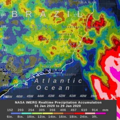
UPDATE 2/12/2020: An extended IMERG analysis of rainfall in Brazil shows even more extreme rainfall occurring in the first weeks of February, with large regions experiencing rainfall totals over 18 inches since the start of 2020. According to local authorities, the region has already received 98% of the rainfall that is typically expected to fall during all of February. UPDATE 1/30/2020: During January 2020, parts of the Brazilian states of Minas Gerais and Espirito Santo experienced above average rainfall, causing deadly floods in the region. Part of the month's heavy rainfall came from a
Typhoon Kammuri Hits the Central Phiippines
While the Atlantic hurricane season officially ended on November 30th, Typhoon Kammuri (known as Tisoy in the Philippines), which recently struck the central Philippines as a powerful Category 4 typhoon, is a reminder that the Pacific typhoon season is not yet over. In fact, while typhoon season does peak from around June through November, similar to the Atlantic, typhoons can occur throughout the year in the Pacific. Kammuri first formed into a tropical depression from an area of low pressure on the 25th of November north of Micronesia in the west central Pacific about 500 miles southeast of Guam.
Typhoon Hagibis Brings Heavy Rains to Japan
Typhoon Hagibis, a once powerful super typhoon, struck the main Japanese island of Honshu over the weekend, bringing very heavy rains and widespread flooding. Hagibis formed into a tropical storm on the 5th of October from a tropical depression that originated from a westward moving tropical wave north of the Marshall Islands. At first, Hagibis strengthened steadily becoming a typhoon about 24 hours after becoming a tropical storm. But, then on the 7th, Hagibis underwent a remarkable rapid intensification cycle and quickly intensified into a super typhoon with sustained winds estimated at 160 mph by the Joint Typhoon Warning Center (JTWC) less than 24 hours after becoming a minimal typhoon.