Extreme Weather News

Jump to a Year

2022 | 2021 | 2020 | 2019 | 2018

2017 | 2016 | 2015 | 2014 | 2013

2012 | 2011 | 2010 | 2009 | 2008

2007 | 2006 | 2005 | 2004 | 2003

2002

Yemen Hit by 2nd Tropical Cyclone in a Week

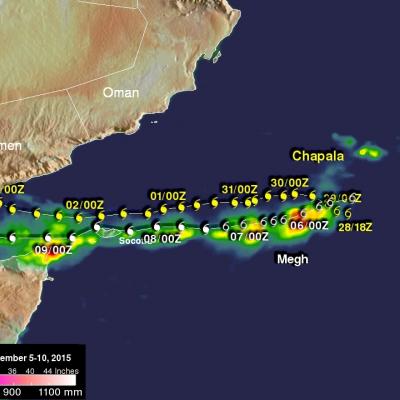
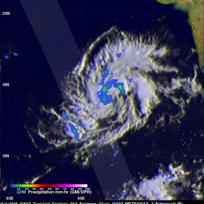
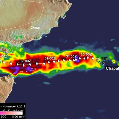
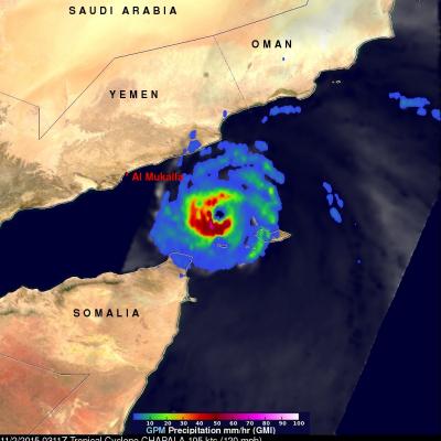
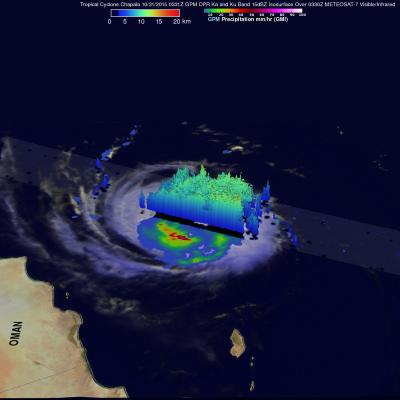
One week ago to the day Cyclone Chapala, the first Category 1 cyclone to strike Yemen in recorded history made landfall on the south-central coast of Yemen, bringing over a year's worth of rain and flooding to that part of the arid country. Today, yet another tropical cyclone, Megh, made landfall in Yemen. Megh, however, made landfall just to the northeast of the coastal city of Aden, which is further west than where Chapala made landfall, and only as a tropical storm. There are, however, several similarities between the two storms. Megh formed in almost the exact same spot in the central

GPM Sees Another Tropical Cyclone Forming

Another tropical cyclone was caught forming by the GPM core Observatory satellite on November 4, 2015 at 1255 UTC. Deadly tropical cyclone Chapala had just dissipated over Yemen when tropical cyclone 05A started forming in the warm waters of the Arabian Sea west of India. GPM measured the rainfall within the forming tropical cyclone using the satellite's Microwave Imager (GMI) and Dual-Frequency Precipitation Radar (DPR) instruments. GMI and DPR found that 05A had scattered light to moderate rainfall falling at a maximum rate of only 23.3 mm (.92 inches) per hour. The Joint Typhoon Warning

Cyclone Chapala Brings Heavy Rains, Flooding to Yemen

Cyclone Chapala, which formed into a rare but powerful Category 4 cyclone in the Arabian Sea with winds at one time estimated at 155 mph by the Joint Typhoon Warning Center (JTWC) back on the 30th of October, made its initial landfall along the south coast of Yemen this morning west of the port city of Mukulla at around 09:00 UTC as a Category 1 cyclone with maximum sustained winds estimated at 75 mph by JTWC, making it the first Category 1 cyclone on record to strike Yemen. The last cyclone to strike the Arabian peninsula was Cyclone Phet, which hit eastern Oman back in 2010. In addition to

GPM Sees Tropical Cyclone Chapala Threatening Yemen

Tropical cyclone Chapala had entered the Gulf Of Aden when the GPM core Observatory satellite passed over on November 2, 1015 at 0311 UTC. Chapala still had maximum sustained winds estimated at about 105kts (121 mph) making it a category three tropical cyclone on the Saffir-Simpson hurricane wind scale. GPM's Microwave Imager (GMI) found that Chapala was dropping rainfall at a rate of over 65 mm (2.6 inches) per hour in intense storms southwest of Chapala's well defined eye. The Joint Typhoon Warning Center (JTWC) predicts that Chapala will weaken before landfall. Chapala is expected to have

GPM Sees Chapala Traveling Toward Yemen

Powerful tropical cyclone Chapala continues moving inexorably toward Yemen. Chapala has weakened from category four intensity a couple days ago while maintaining a course that steers it toward Yemen. The GPM core observatory satellite had a good look at tropical cyclone Chapala on October 31, 2015 at 0331 UTC. GPM's rainfall data are shown overlaid on a 0330Z METEOSAT-7 Visible/Infrared image. At that time Chapala was a very powerful tropical cyclone with maximum sustained winds of about 117 kts (135 mph). GPM's Microwave Imager (GMI) instrument measured rain dropping at a rate of over 88 mm