Why are we looking at landslides?
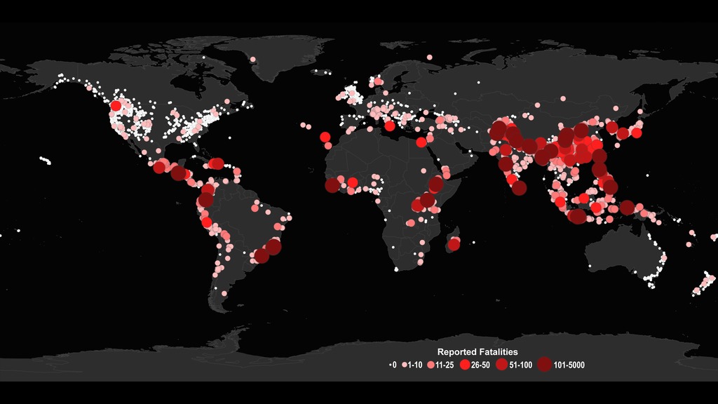
Landslides cause billions of dollars in infrastructural damage and thousands of deaths every year around the world.
However, to date we do not have a global picture of exactly where and when landslides occur owing to their small size and difficulty in identifying their onset and extent when no one is around to witness their impacts. The Cooperative Open Online Landslide Repository (COOLR) project provides an open platform where scientists and citizen scientists around the world can share landslide reports to guide awareness of landslide hazards for improving scientific modeling and emergency response. Scientists and citizen scientists can submit landslides to the Landslide Reporter web application, or submit landslide inventories directly to us. All the data submitted is made available on the data portal Landslide Viewer, which shows referenced and imported landslide inventories from all over the world.
What is COOLR?
The Cooperative Open Online Landslide Repository (COOLR) is comprised of information from around the world. COOLR currently includes:
- Report-based landslide inventories: contains NASA’s Global Landslide Catalog; contributed inventories from other institutions; and landslides reported by citizen scientists (Landslide Reporter Catalog) through Landslide Reporter.
- Event-based landslide inventories: contains NASA’s automated (utilizing SALaD) or manually digitized landslides, and contributed inventories from other institutions.
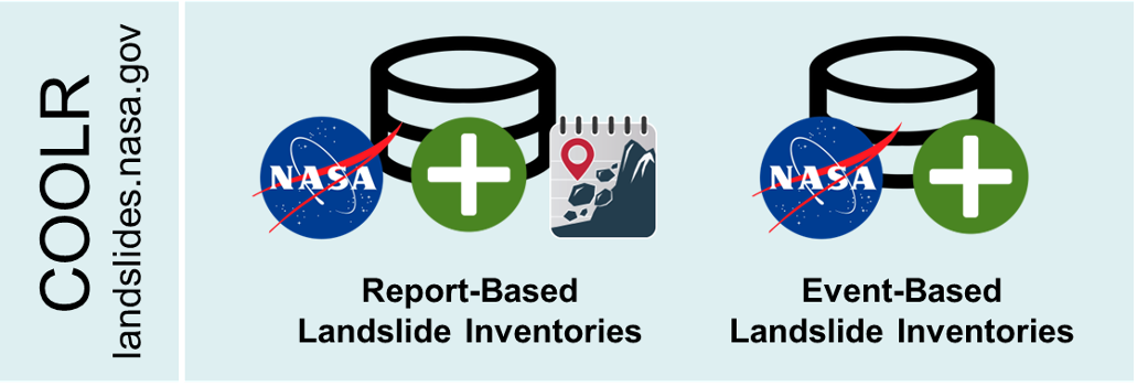
COOLR also includes references to other public landslide databases, which can be seen at Landslide Viewer.
Why are citizen scientists needed?
Our team at NASA has been collecting recorded landslides around the world since from 2007 to 2018 in the Global Landslide Catalog (GLC). In addition, NASA has been automatically (using SALaD) and manually digitizing landslides in the event-based landslide inventory.. The GLC and the event-based inventories provides new insight into landslide hazards around the world, but it has been a manual and very time -consuming process that is hard to maintain. If we sum up all the labor it has taken to compile this inventory, it would total more than 1.6 years of effort! The inventory is also challenged by biases affecting where and when landslide information is available (for more details please see the Publications).
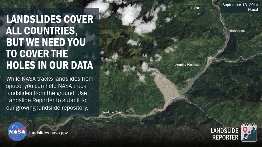
We are appealing to the global citizen science community to help advance our knowledge of where and when landslides are happening around the world by adding reports to fill in the gaps in our data, creating the Cooperative Open Online Landslide Repository (COOLR). Citizen scientists are people like you who can use their knowledge to advance scientific research and grow our collective understanding of this pervasive hazard.
Citizen science can help:- Find information from many different sources, and with as little bias as possible, including local first-hand accounts, reports in other languages, and points from other inventories for a robust landslide repository.
- Collect recent landslides and keep the repository up to date.
- Create more awareness and education about landslides as a natural process and natural/man-made hazard.
With the help of citizen scientists like you, we can improve both the quantity and quality of open landslide data to provide a clearer picture of how landslides are shaping our world.
What happens to the data?
Landslides collected in COOLR help NASA scientists with their research. COOLR is used to validate the Landslide Hazard Assessment for Situational Awareness (LHASA) model developed at NASA Goddard Space Flight Center (GSFC). COOLR data is compared to the LHASA model "nowcasts" to verify the accuracy of the model. Since most landslides occur in places with no observations, it is not possible to verify its accuracy in all areas. We need a more robust landslide inventory to improve this model, which is where citizen science can help. For links to the LHASA publication and more information about the model, see the Resources page.
The global data is also openly available online for other scientific groups to view and download, on the data portal Landslide Viewer. If you use COOLR in your research publication, we request that you reference the data following the citation instructions on the COOLR Data page.
Next Steps: Get Started with COOLR
Visit Report Landslides to find out how you can access the data, learn more about landslides, and contribute to advancing landslide science and emergency response by adding your own reports.
Report Landslides »Frequently Asked Questions
General
+Is my information tied to my landslide reports and made publicly available on COOLR?Landslide Reporter
+Can I edit/delete my report after I submitted it?+Can I see all my past reports that were accepted to COOLR?
+Are the submissions quality-checked before they are added to COOLR?
Data Download and Analysis
+Can I download COOLR for my research?+Is COOLR data currently being used for landslide research?
Connect with Us
Twitter: @LandslideReport
Facebook: LandslideReporter
SciStarter: Join us on our project page
Connect with the Community
Google Groups: Landslide Reporter Community
Contact Us
For any questions related to this system, please contact landslide_support@nccs.nasa.gov.