
Landslide Reporter is the submission portal for COOLR. When you find a landslide event through a news article or in-person, you can open the web application to add information about the location, date, type of landslide, and other details about the event in Landslide Reporter.
Landslide Reporter Quick Start
Contents
Accessing the Application
Landslide Reporter can be accessed via internet by your computer or mobile device. The URL for reaching Landslide Reporter is
You will need a Facebook account or Google account to log in. Logging in will allow you to access your previous submissions. Your credentials will not be publicly linked to your reports in the online database. Please see our privacy policy for more information.
Upon signing in, you will be presented with the Terms and Conditions of using Landslide Reporter. You must check the box and agree to the Terms and Conditions before you can use the application.
Once logged in, your browser may ask you to use your location. Click “Accept” or “Allow” so that the browser can pinpoint your current location, making it easier for you to submit local events.
Using Landslide Reporter on the Web
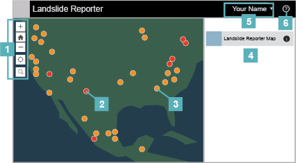
Main screen
- Map navigation: Zoom and search for locations
- Red points or polygons: Your previously-submitted landslide reports.
- Landslide Reporter Map Sidebar: The sidebar for submitting new landslide reports to the database. See the how-to guides for how to submit a report.
- Orange points or polygons: Landslide events added to the Cooperative Open Online Landslide Repository (COOLR). Cannot be clicked.
- Username/Menu: Opens a drop-down menu to see your previous submissions or log out of your account.
- Terms and Conditions: Opens the Terms and Conditions for using Landslide Reporter.
Using Landslide Reporter on your Mobile Device
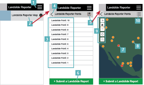
Main screen
- Menu: See your previous submissions, review the Terms and Conditions of using Landslide Reporter, or sign out of your account.
- Landslide Reporter Map: The main screen for submitting new reports to the database or viewing the map. See the how-to guides for how to submit a report.
After selecting the appropriate Landslide Reporter Map submission option, Points or Polygons, the main screen will change to display a list of your previous submissions.
- GLC Event List: List of all your previously-submitted reports, either all points or all polygons.
- Back arrow: Sends the sidebar to the previous screen.
- Map view: Opens the Map view, a map display with your and COOLR's landslide points.
- Submit a Landslide Report: The green button will open the Landslide Reporter submission form. See the how-to guides for how to submit a report.
- Red points or polygons: Your previously-submitted landslide reports (either points or polygons depending on your Landslide Reporter Map sidebar selection). Click a report to open up the details about the event.
- Orange points or polygons: Landslide events added to the Cooperative Open Online Landslide Repository (COOLR). Cannot be clicked.
- Map navigation: Zoom and search for locations.
- List view: The “list” icon returns you to the List view
Related Pages
Connect with Us
Twitter: @LandslideReport
Facebook: LandslideReporter
SciStarter: Join us on our project page
Connect with the Community
Google Groups: Landslide Reporter Community
Contact Us
For any questions related to this system, please contact landslide_support@nccs.nasa.gov.