Browse Resources
Browse Resources

Primary Topic:
Subtopics:
Type:
Keywords:
Summary:
Part 3 of a 4 part webquest that teaches the basics of precipitation science and technology. Prepares students for the GPM Anime Contest.

Primary Topic:
Subtopics:
Type:
Summary:
Part 2 of a 4 part webquest that teaches the basics of precipitation science and technology. Prepares students for the GPM Anime Contest.

Primary Topic:
Subtopics:
Type:
Summary:
Part 1 of a 4 part webquest that teaches the basics of precipitation science. Prepares students for the GPM Anime Contest.

Primary Topic:
Subtopics:
Type:
Keywords:
Summary:
This poster for the Global Precipitation Measurement mission (GPM) shows the GPM Core Observatory and constellation satellites on the front, and GPM information and educational activities on the back.

Primary Topic:
Subtopics:
Type:
Keywords:
Summary:
An informational lithograph / handout which shows images of the GPM Core Observatory and constellation satellites, and explains the goals and methods of the GPM mission.
Primary Topic:
Subtopics:
Type:
Keywords:
Summary:
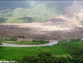
This article explains how NASA scientists use TRMM satellite rainfall data to help predict and prepare for landslides.

Primary Topic:
Subtopics:
Type:
Keywords:
Summary:
Interview with Dr. Dalia Kirschbaum, research physical scientist and GPM Applications Scientist at NASA Goddard Space Flight Center.

Primary Topic:
Subtopics:
Type:
Standards:
Keywords:
Summary:
This booklet explains the basics of weather satellites and contains activities to explain questions like "How does a satellite stay up in space without falling back to Earth? "

Primary Topic:
Subtopics:
Type:
Keywords:
Summary:
How do hurricanes get their energy? NASA hurricane scientist Dr. Jeff Halverson explains how hurricanes draw energy from the ocean surface.

Primary Topic:
Subtopics:
Type:
Standards:
Keywords:
Summary:
Using data from various satellites, these images show maps of the location of world droughts compared to where crops are grown.