Browse Remote Sensing Resources
Browse Remote Sensing Resources

Primary Topic:
Subtopics:
Type:
Keywords:
Summary:
This classroom activity (originally developed for the GPM Poster) will teach students about the value of Earth's freshwater resources and how important it is to study how water is transferred and stored.

Primary Topic:
Subtopics:
Type:
Keywords:
Summary:
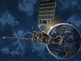
This poster for the Global Precipitation Measurement mission (GPM) shows the GPM Core Observatory and constellation satellites on the front, and GPM information and educational activities on the back.

Primary Topic:
Subtopics:
Type:
Keywords:
Summary:
An informational lithograph / handout which shows images of the GPM Core Observatory and constellation satellites, and explains the goals and methods of the GPM mission.
Primary Topic:
Subtopics:
Type:
Keywords:
Summary:
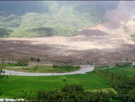
This article explains how NASA scientists use TRMM satellite rainfall data to help predict and prepare for landslides.

Primary Topic:
Subtopics:
Type:
Keywords:
Summary:
Interview with Dr. Dalia Kirschbaum, research physical scientist and GPM Applications Scientist at NASA Goddard Space Flight Center.

Primary Topic:
Subtopics:
Type:
Standards:
Keywords:
Summary:
This booklet explains the basics of weather satellites and contains activities to explain questions like "How does a satellite stay up in space without falling back to Earth? "

Primary Topic:
Subtopics:
Type:
Keywords:
Summary:
During the past decade, groundwater beneath the northern Indian states of Punjab, Haryana, and Rajasthan has decreased by more than 88 million acre-feet. Using NASA's twin GRACE satellites, scientists determined the rate of groundwater change in India.

Primary Topic:
Subtopics:
Type:
Standards:
Keywords:
Summary:
Heavy spring rains and snowmelt led to devastating floods along the Mississippi River in May 2011. Landsat 5 flew over the Mississippi River on May 10, 2011, giving a distinct view of the extraordinary extent of the flooding.

Primary Topic:
Subtopics:
Type:
Keywords:
Summary:
Hurricane Irene's impact in New England shows that tropical cyclones can greatly affect regions outside the view of TRMM. The GPM mission will build upon TRMM's legacy by examining a larger swath of Earth with more sensitive instruments.
Primary Topic:
Subtopics:
Type:
Standards:
Keywords:
Summary:
Satellites can orbit Earth's equator or go over Earth's North and South Poles, or anything in between. They can orbit at a low altitude, or thousands of miles out in space. The choice of orbit all depends on the satellite's job.