Browse ESS3.B Resources
Browse ESS3.B Resources

Primary Topic:
Subtopics:
Type:
Keywords:
Summary:
Satellite Meteorology learning modules provide scientists and educators with exciting activities and hands-on tools for investigation, inquiry, analysis and stewardship.

Primary Topic:
Subtopics:
Type:
Summary:
Part 4 of a 4 part webquest that teaches the basics of precipitation science and technology. Prepares students for the GPM Anime Contest.
Primary Topic:
Subtopics:
Type:
Keywords:
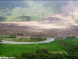
Summary:
This article explains how NASA scientists use TRMM satellite rainfall data to help predict and prepare for landslides.

Primary Topic:
Subtopics:
Type:
Keywords:
Summary:
Interview with Dr. Dalia Kirschbaum, research physical scientist and GPM Applications Scientist at NASA Goddard Space Flight Center.

Primary Topic:
Subtopics:
Type:
Keywords:
Summary:
How do hurricanes get their energy? NASA hurricane scientist Dr. Jeff Halverson explains how hurricanes draw energy from the ocean surface.

Primary Topic:
Subtopics:
Type:
Standards:
Keywords:
Summary:
Heavy spring rains and snowmelt led to devastating floods along the Mississippi River in May 2011. Landsat 5 flew over the Mississippi River on May 10, 2011, giving a distinct view of the extraordinary extent of the flooding.

Primary Topic:
Subtopics:
Type:
Keywords:
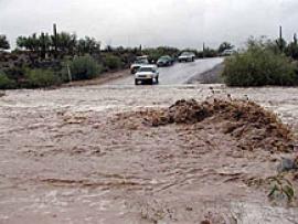
Summary:
Hurricane Irene's impact in New England shows that tropical cyclones can greatly affect regions outside the view of TRMM. The GPM mission will build upon TRMM's legacy by examining a larger swath of Earth with more sensitive instruments.

Primary Topic:
Subtopics:
Type:
Keywords:
Summary:
See Landsat images before and after these natural disasters.

Primary Topic:
Subtopics:
Type:
Keywords:
Summary:
View before and after images of natural disasters and human impact in various locations around the world.
Primary Topic:
Subtopics:
Type:
Keywords:
Summary:
Faisal Hossain, a civil and environmental engineering professor at Tennessee Technological University, uses NASA satellite data to help Bangladeshi authorities monitor their water resources and prepare for water-related disasters.