Browse Societal Applications Resources
Browse Societal Applications Resources

Primary Topic:
Subtopics:
Type:
Standards:
Keywords:
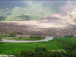
Summary:
Students will investigate the effect of different types of soil on how quickly a landslide occurs and how much mass is moved. They will then relate that information to TRMM/GPM data about rainfall and areas currently at risk of suffering a landslide.

Primary Topic:
Subtopics:
Type:
Keywords:
Summary:
Researchers need accurate and timely rainfall information to better understand and model where and when severe floods, frequent landslides and devastating droughts may occur, and GPM’s global rainfall data will help provide that information.

Primary Topic:
Subtopics:
Type:
Keywords:
Summary:
This is an introductory lesson to acquaint middle school students to many aspects of a serious and common natural disaster; flooding. Students will be directed to visit websites where they will interact with various types of media.

Primary Topic:
Subtopics:
Type:
Keywords:
Summary:
This classroom activity (originally developed for the GPM Poster) will teach students about the value of Earth's freshwater resources and how important it is to study how water is transferred and stored.
Primary Topic:
Subtopics:
Type:
Keywords:
Summary:
This article explains how NASA scientists use TRMM satellite rainfall data to help predict and prepare for landslides.

Primary Topic:
Subtopics:
Type:
Keywords:
Summary:
How do hurricanes get their energy? NASA hurricane scientist Dr. Jeff Halverson explains how hurricanes draw energy from the ocean surface.

Primary Topic:
Subtopics:
Type:
Keywords:
Summary:
When drought occurs, water supplies for agriculture, industry, and personal use decrease, and people need to find ways to cope with the shortage or leave the area. This series of lesson plans teaches students about the science of droughts.

Primary Topic:
Subtopics:
Type:
Standards:
Keywords:
Summary:
Using data from various satellites, these images show maps of the location of world droughts compared to where crops are grown.

Primary Topic:
Subtopics:
Type:
Keywords:
Summary:
During the past decade, groundwater beneath the northern Indian states of Punjab, Haryana, and Rajasthan has decreased by more than 88 million acre-feet. Using NASA's twin GRACE satellites, scientists determined the rate of groundwater change in India.

Primary Topic:
Subtopics:
Type:
Standards:
Keywords:
Summary:
Heavy spring rains and snowmelt led to devastating floods along the Mississippi River in May 2011. Landsat 5 flew over the Mississippi River on May 10, 2011, giving a distinct view of the extraordinary extent of the flooding.