Browse Floods Resources
Browse Floods Resources
Primary Topic:
Subtopics:
Type:
Keywords:
Summary:
Hurricane Irene's impact in New England shows that tropical cyclones can greatly affect regions outside the view of TRMM. The GPM mission will build upon TRMM's legacy by examining a larger swath of Earth with more sensitive instruments.
Primary Topic:
Subtopics:
Type:
Keywords:
Summary:
This website describes a study that is being conducted to understand the complexities of rainfall patterns and their effects on food security and human mobility.
Primary Topic:
Subtopics:
Type:
Keywords:
Summary:
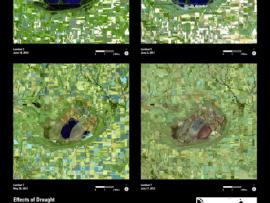
See Landsat images before and after these natural disasters.
Primary Topic:
Subtopics:
Type:
Keywords:
Summary:
View before and after images of natural disasters and human impact in various locations around the world.
Primary Topic:
Subtopics:
Type:
Keywords:
Summary:
Faisal Hossain, a civil and environmental engineering professor at Tennessee Technological University, uses NASA satellite data to help Bangladeshi authorities monitor their water resources and prepare for water-related disasters.
Primary Topic:
Subtopics:
Type:
Standards:
Keywords:
Summary:
Using satellites, lasers, and radar in space, and dedicated researchers on the ground, NASA is studying the Earth's ice and water to better understand how sea level rise might affect us all.


