Edilson

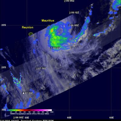
TRMM Visits Edilson Again

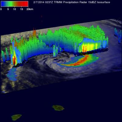
The TRMM satellite had an excellent early morning look at Edilson on February 7, 2014 at 0237 UTC (~ 0628 local time) when it passed directly above the tropical cyclone . A rainfall analysis from TRMM's Microwave Imager (TMI) and Precipitation Radar (PR) instruments is shown overlaid on an enhanced visible/infrared image from TRMM's Visible and InfraRed Scanner (VIRS). The area covered by TRMM's Precipitation radar (PR) data is shown in a lighter shade. Those data show Edilson south of Reunion and Mauritius Islands dropping it's heaviest rain at a rate of over 175mm/hr (~6.9 inches) in an

Tropical Cyclone Edilson Near Mauritius

Tropical Cyclone Edilson was passing close to the islands of Mauritius and Reunion, in the south Indian Ocean, when the TRMM satellite flew above on February 6, 2014 at 0332 UTC. Rainfall from TRMM's Microwave Imager (TMI) and Precipitation Radar (PR) instruments is shown overlaid on an enhanced visible/infrared image from TRMM's Visible and InfraRed Scanner (VIRS). TRMM TMI data showed that moderate to heavy rain was falling at a rate of over 30mm/hr (about 1.1 inches) just to the southeast of Mauritius. With sustained winds of about 55kts (~63 mph), Edilson is much weaker than deadly