

Validation
Direct Statistical Validation
A GPM Ground Validation prototype is currently underway to compare TRMM satellite data to similar measurements from the national network of operational weather radars. The goal of the Validation Network is to identify and resolve significant discrepancies between the US national network of ground radar observations and satellite observations.
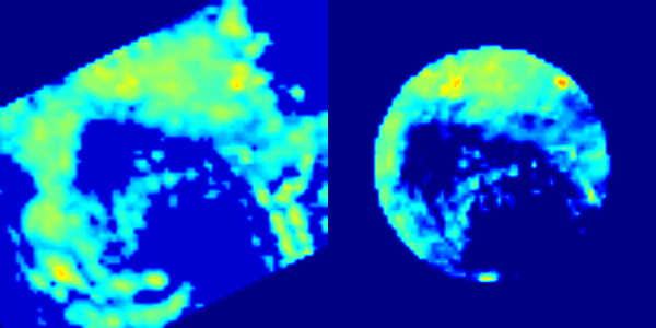
The validation network prototype matches-up TRMM Precipitation Radar (PR, see below image) and quality-controlled NEXRAD reflectivity data (right) for 21 ground radar sites in the Southeastern United States. Conceptually, the Validation Network also extends to include targeted hydrometeorological assets external to continental US (e.g., Kwajalein and other national networks). The ultimate goal of such comparisons is to understand and resolve the first order variability and bias of precipitation retrievals in different meteorological/hydrological regimes at large scales. Match-up data sets in the form of netCDF files are available starting from August 2006.
Links on this page provide access to the data sets and supporting software and documentation. Please contact the Ground Validation team if you want additional information.
Direct Statistical Validation Links
- VN data archive
- VN Data Product User's Guides: Volume 1 (TRMM), Volume 2 (GPM)
- VN open source software
- VN publications
- VN points-of-contact
Other Direct Validation Frameworks
The Coordination Group for Meteorological Satellites (CGMS) supports the International Precipitation Working Group (IPWG) as forum for operational and research users of satellite precipitation measurements. The goal of the IPWG is to exchange information on methods for measuring precipitation and the impact of space borne precipitation measurements in numerical weather and hydrometeorological prediction and climate studies. The IPWG web site has links to data, products and tools of interest to precipitation ground validation.
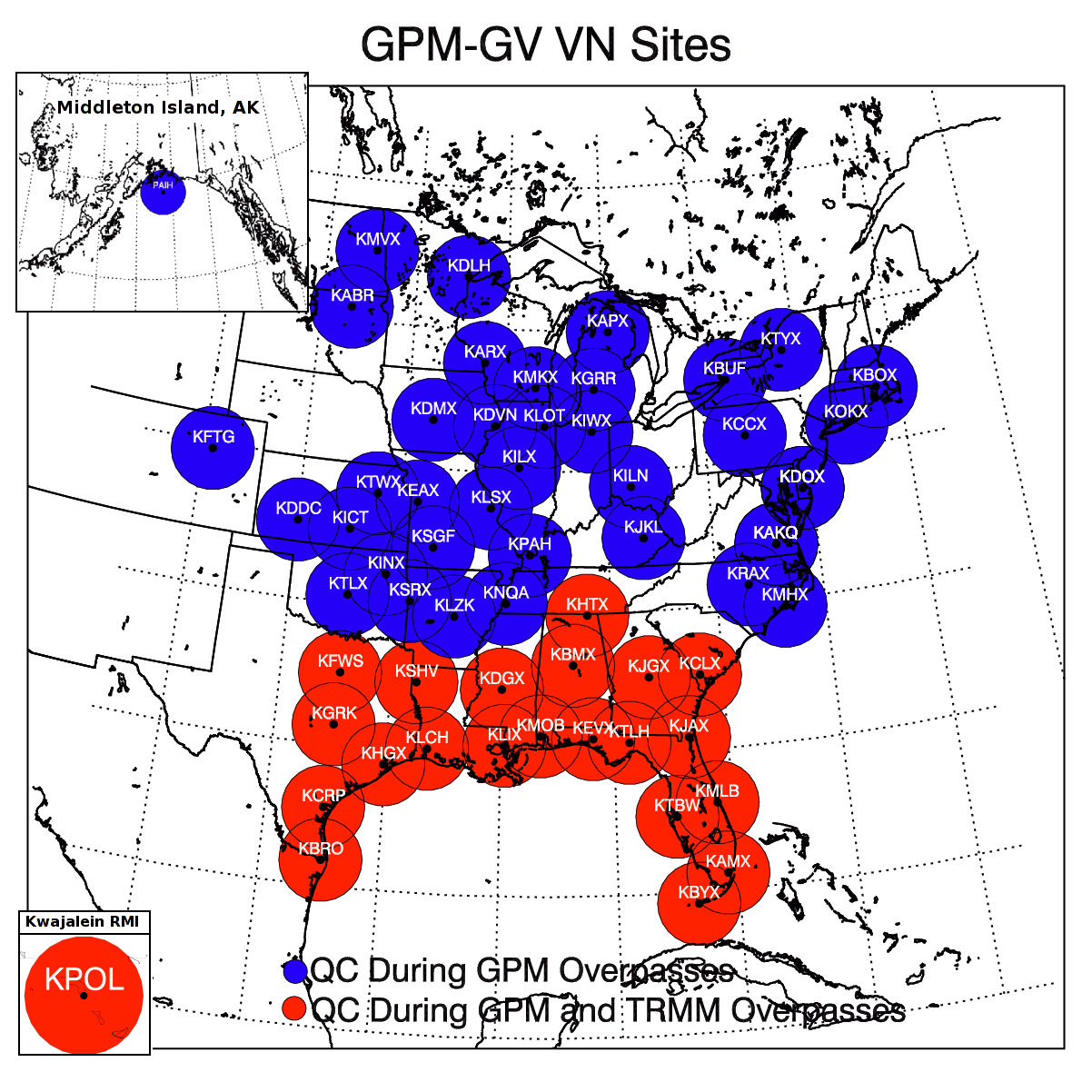
Location of radars in the Validation Network. Red circles indicate the original set used with TRMM, and blue circles indicate new radars to be used with GPM.
The National Mosaic and Multi-Sensor QPE (NWQ) serves as an international testbed for research, development, evaluation, science and operations. The NWQ uses high resolution 3D Mosiac of multiple radars and radar networks for model assimilation and aviation applications, Quantitative Precipitation Information (QPI) including Multiple Sensor Quantitative Precipitation Estimation (MSQPE) and Very Short Term Quantitative Precipitation Forecasts (VSTQPF) for the monitoring and warnings of floods and flash floods, and in support of comprehensive hydrology and ecosystem modeling.
Physical Validation
Physical validation activities collect targeted datasets that describe precipitation physics: the size, type, shape and number of raindrops throughout the air column from the cloud to the ground. Scientists use ground validation measurements to evaluate specific assumptions or hypotheses related to the physical behavior of precipitation, and the manner in which those characteristics are, or are not, well represented in a given retrieval algorithm. The goal of this validation process is to improve and fully develop physically-based precipitation retrieval algorithms. These algorithms are the first step to achieving GPM's applications objectives related to accurately characterizing rain and snow throughout many different types of precipitating systems.

GPM ground validation uses a well-established strategy of overlapping field measurements of rain's physical properties. The measurements are made with dual-frequency radar and multi-frequency radiometer remote sensors, characteristic of GPM satellite instruments. These field measurements are conducted using:
- Ground level suites of high density disdrometer and rain gauge instruments to characterize precipitation properties and variability
- Multi-frequency/polarimetric radar and profiler observations of cloud microphysical properties and rainfall from the surface through the atmospheric column
- Direct in-situ and profiling aircraft measurements providing detailed particle microphysical information (sizes, shapes, types, numbers etc.) and evolution in the column as rain falls to the ground that can then be compared with radar observations
- High-altitude airborne (NASA ER-2, DC-8) dual-frequency radar and multi-frequency radiometers that mimic measurements made by the GPM Core and constellation satellites.
Integrated Hydrological Validation
Integrated hydrologic validation assesses GPM precipitation products by considering how the accuracy of rainfall products being input into hydrological and land-surface modeling affects model outputs. The end goals are to evaluate satellite precipitation measurements for their impacts and utility, and to provide guidance to algorithms that turn satellite retrievals into meaningful estimates of precipitation.
The integrated hydrologic modeling process provides a vehicle to evaluate precipitation inputs over a given hydrological basin (watershed) where the surface inputs (land cover, soil type) are already known within a given uncertainty level. The hydrologic model then uses the GPM precipitation products and compares hydrologic model outputs to results collected in the field. Discrepancies between the two sets of results can then be used as a form of guidance for refining the GPM algorithms that provide the precipitation products.
The integrated ground validation effort also evaluates the impact that GPM products have on different time and spatial scales for applications including flood prediction, water resource monitoring and closure of basin to regional scale water budgets.
Finally, because characteristics such as soil moisture or the presence of snow on the ground affect the background emissivity detected by passive microwave measurements, the measurements made during ground validation campaigns provide input to refine GPM Microwave Imager (GMI) physically-based retrieval algorithms - especially for those algorithms developed to work over land.