
Powerful Cyclone Narelle makes multiple landfalls in Australia
After intensifying into a powerful Category 4 cyclone (Category 5 on the Australian scale) in the Coral Sea, Narelle made landfall on the east coast of Queensland, before continuing on across the Northern Territory, and turning south to make landfall yet again in Western Australia. Along the way, Narelle brought gusty winds and heavy rains to all three regions.
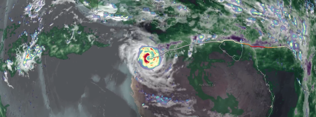
Narelle first began as a westward-moving area of low pressure south of the Solomon Islands. Warm sea surface temperatures (SSTs), weakening wind shear, and persistent convective activity allowed the circulation to organize such that the US Joint Typhoon Warning Center (JTWC) and Australian Bureau of Meteorology’s Tropical Cyclone Warning Centre upgraded the system to a tropical cyclone on the 17th of March as it was moving west-southwest through the north-central Coral Sea. As Narelle continued westward across the northern Coral Sea, highly favorable environmental conditions of warm SSTs of around 29 °C (~84 °F) or more and low wind shear set the stage for a period of rapid intensification with Narelle intensifying from a Category 1 cyclone on the US Saffir-Simpson scale on the 18th of March into a Category 4 storm with maximum sustained winds estimated at 145 mph by JTWC on the 19th of March as it approached the York Peninsula in Queensland. Narelle made its first landfall on a remote stretch of the northern York Peninsula south of Lockhart River just before 21:00 UTC on March 19th (11:00 am 20 March AEST) as a Category 4 cyclone with sustained winds of around 135 mph. Wind gusts were reported to have reached 115 kph (71 mph) in Lockhart River and 109 kph (68 mph) in Weipa.
After crossing the York Peninsula, Narelle re-emerged over the Gulf of Carpentaria south of Weipa near Aurukun on the evening of March 20th (local time). Continuing westward, Narelle’s passage over land had weakened it back down to a Category 1 storm with sustained winds of 75 mph by the early morning hours of the 21st, before starting to become re-energized by SSTs again exceeding 29 °C in the Gulf. This allowed Narelle to make its 2nd Australian landfall in the Northern Territory, in a remote area near the mouth of the Walker River, around 3:00 am (local time) on the 22nd as a high-end Category 1 storm with sustained winds of 90 mph.
Over the next day, Narelle remained well inland as it crossed the northern part of the Northern Territory, causing the storm to weaken substantially. When the storm emerged off of the coast south of Wadeye into the southern Joseph Bonaparte Gulf on the morning of March 23rd, sustained winds had dropped to just 40 mph, making it equivalent to a tropical depression on the US scale. The center spent a brief roughly 7 hours over water before making landfall a 3rd time in yet another remote area with sustained winds estimated at 45 mph (equivalent to a weak tropical storm), this time in far northeastern Western Australia.
Once again, Narelle weakened down to a tropical depression with maximum sustained winds of roughly 40 mph as it remained inland for the better part of a day over the northern coast of Western Australia. The storm then re-emerged over warm waters yet again, this time over the far eastern Indian Ocean on the morning of the 24th (local time), and this time Narelle would remain over warm open water for much longer, allowing it to re-intensify significantly.
As Narelle emerged off the northwest coast of Western Australia and into the Indian Ocean, it also reached the western edge of a sub-tropical ridge located over central-west Australia. This caused Narelle to begin to recurve to the south. The storm quickly responded to the warm waters of the Indian Ocean, and after just over 24 hours over water at 2:00 pm on the 25th (AWST), Narelle’s maximum sustained winds had increased to 80 mph, and by 8:00 pm, they were 100 mph. Narelle would go on to reach its peak intensity over the Indian Ocean the next day at 8:00 pm (AWST) with maximum sustained winds of 130 mph, equivalent to a minimal Category 4 hurricane on the US scale. By now, Narelle was moving southwest and continuing to recurve as it neared the far west coast of Western Australia. Narelle then hooked around the North West Cape before making its 4th and final landfall in Western Australia just south of Coral Bay at around 2:00 pm on March 27th (AWST) with maximum sustained winds estimated at 95 mph, equivalent to a strong Category 1 hurricane. More than 200 buildings were reported to have been damaged in the town of Exmouth, which was impacted by the strong winds on the eastern side of the storm as the center passed just offshore. The town was also cut off by flood waters.
When Narelle made its final landfall, it was moving almost due south. The storm then continued to re-curve ahead of an approaching upper-level trough moving in from the west, which resulted in Narelle taking a southeast track inland across western Western Australia with the center passing about 150 miles east of Perth. After landfall, Narelle steadily weakened to a tropical depression.
The following animation shows surface rainfall estimates from NASA’s IMERG precipitation product in association with Narelle with alternating light and dark backgrounds indicating the day/night cycle. The animation begins at 00:00 UTC 15 March 2026 when Narelle was still in the process of forming south of the Solomon Islands, through its multiple landfalls, and ends at 23:30 UTC 28 March 2026 when Narelle’s remaining circulation exited the southern coast of Western Australia. IMERG shows the heaviest rains (200 to 400 mm, ~8 to 16 inches, shown in purple) largely remained offshore on the right side of Narelle’s track where the storm’s circulation had more access to moisture from the ocean. Over land, the heaviest rainfall occurred over parts of the northern York Peninsula and northern Northern Territory where IMERG shows over 200 mm (~8 inches) of rainfall. Weipa, located on the northwest coast of the York Peninsula reported 217 mm of rain from the storm. In general, Narelle brought about 25 to 100 mm (~1 to 4 inches, shown in green) with some locally higher amounts to nearly the entire northern coast of Australia as well as a significant part of Western Australia. NASA's RAIN-Global 2 visualization tool can be used to view these precipitation estimates from Narelle, as well as from other extreme weather events globally.
Credits:
Story by Steve Lang (NASA GSFC/STC).
Animation by Jason West (NASA GSFC/PPS/KBR).