

Freshwater Availability
This video is public domain and can be downloaded at: http://svs.gsfc.nasa.gov/goto?11619
Southeastern Australia recently experienced a 13-year drought, which is unprecedented in the historical record. The drastic drop in rainfall each year led to consequent drops in runoff and streamflow that left the government scrambling for solutions in this agricultural region. The drought was then followed by devastating floods in late 2010 and early 2011, which put more than 75 towns under water and ranks as one of the costliest disasters in Australia’s history (source). While the immediate damage has been horrific both in destruction of property and cost, the long term effects of yearly and decade long swings in rainfall patterns, like the one seen in Australia, can significantly impact groundwater, an important component of the water cycle that is difficult to quantify due to varying geological structures of aquifers and human interaction. When groundwater supply changes so do water supplies for irrigation and drinking water.
Putting a number on the variability of extreme flood or drought conditions is vital to understanding and forecasting the availability freshwater resources worldwide. TRMM and GPM, together with other NASA earth observing missions, provide useful rainfall estimates at regional and global scales to help scientists understand extreme droughts or floods and consequent freshwater availability. Many indices, including the U.S. Drought Monitor, Palmer Drought Severity Index (PDSI), and Precipitation Drought Severity Index (Changnon 1989), draw a direct link between the abundance or deficit of precipitation over a region and groundwater availability.
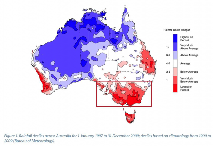 Synthesis Report from Phase 1 of South Eastern Australian Climate Initiative (SEACI), http://www.seaci.org/, page 6.