
GPM Examines Upgraded Hurricane Leslie
![]()
The GPM core observatory satellite passed above hurricane Leslie on October 3, 2018 at 7:33 AM EDT (1133 UTC). Leslie had just been upgraded to a hurricane by the National Hurricane Center (NHC). GPM's Microwave Imager (GMI) instrument collected data that revealed light to moderate convective rainfall in Leslie's clearly evident eye wall. Very little precipitation was shown by GPM in the center of the hurricane's nearly circular eye. Algorithms developed by NASA's Precipitation Measurement Missions (PMM) science team indicated that rain was falling at over 1.8 inches (45.7 mm) per hour within storms located in the northwestern side of the Leslie's eye wall.
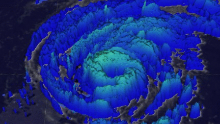
This 3-D animation shows the estimated heights of storms within hurricane Leslie at the time of this GPM satellite pass. Storm top heights are based on data observed by GPM's Dual Frequency Precipitation Radar (DPR Ku Band) blended with estimates based on geostationary satellite cloud top temperatures.
The National Hurricane Center (NHC) predicts that Leslie will move toward the north over the open waters of the Atlantic Ocean for two or three days. Then Leslie is expected to be steered toward the east as a trough dips southward over the north Atlantic. Large swells, propagated toward the southwest by Leslie, are expected to be the only evidence of the hurricane's existence to residents living along the southeastern coast of the United States.