
GPM IMERG Adds Up Heavy Rains from Typhoon Jebi
Typhoon Jebi brought flooding to Japan and NASA’s IMERG estimated rainfall over the country and the surrounding region for a one-week period.
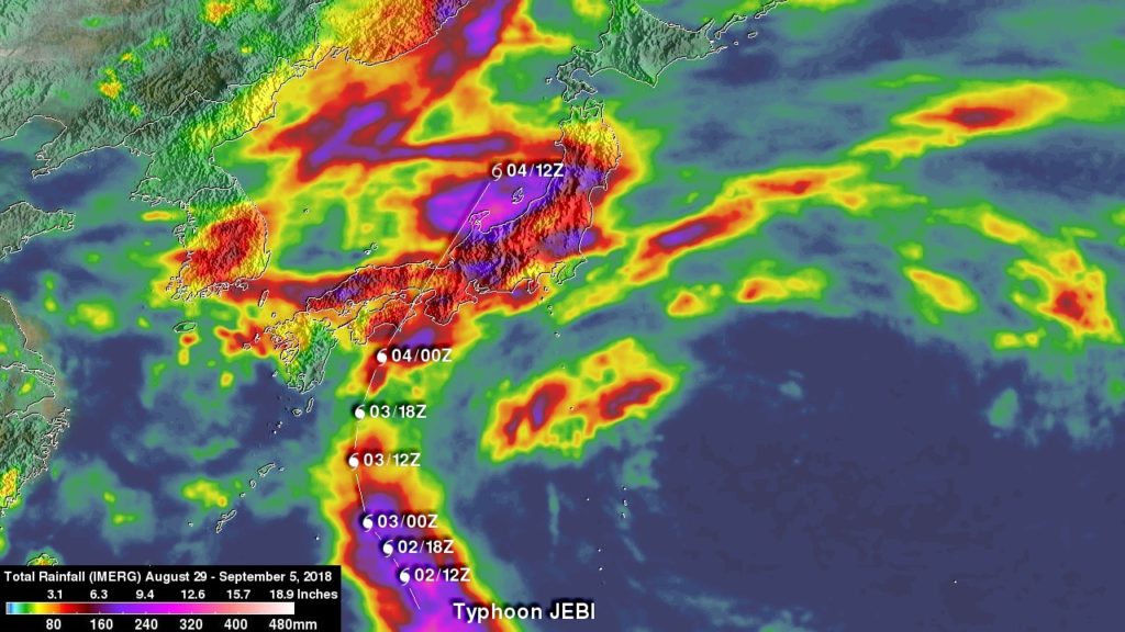
The above image shows accumulated IMERG rainfall estimates over Japan and the surrounding region for the 1-week period from August 29 to Sept. 5, 2018 show rainfall amounts on the order of 100 mm (~4 inches, shown in red) or more covering much of the main island of Honshu and Shikoku in the south. Much of the band of rain oriented east-west across central Japan was due to a frontal system that brought rain to the area before Jebi made landfall.
Super Typhoon Jebi began as an area of low pressure that formed in the vicinity of Enewetak Atoll in the far western Marshall Islands. Two days later on the 27th of August the system was upgraded to a tropical depression, which continued to intensify, becoming a named tropical storm, the 21st of the season, the following day.
After initially moving northwest, Jebi took a more westward track and continued to steadily intensify as it approached the Northern Mariana Islands, becoming a typhoon on the 29th, a Category 3 typhoon on the 30th, and finally a super typhoon on the 31st of August (local time) just after it passed between the islands of Pagan and Alamagan in the Northern Marianas. Jebi then reached its peak intensity with sustained winds estimated at 175 mph by the Joint Typhoon Warning Center as it made its way into the Philippine Sea. Over the central Philippine Sea, Jebi began to recurve toward the northwest before eventually turning northward under the influence of an upper-level trough as it neared Japan.
As is often the case, the wind shear associated with the change in direction helped to weaken Jebi as it approached the southern part of Japan. Nevertheless, Jebi was the strongest typhoon to make landfall in Japan in 25 years when it came ashore over the eastern end of Shikoku, the smallest of Japan’s four main islands, Tuesday, September 4th around noon (local time), where winds gusts of up to 129 mph were reported. Jebi then crossed the southern coast of the main island of Honshu near Kobe, bringing heavy rains and high winds to the region.
The Integrated Multi-satellitE Retrievals for GPM (the Global Precipitation Measurement mission) or IMERG is used to estimate precipitation from a combination of passive microwave sensors, including GPM’s GMI microwave sensor and geostationary IR (infrared) data. Accumulated IMERG rainfall estimates over Japan and the surrounding region for the 1-week period from August 29 to Sept. 5, 2018 show rainfall amounts on the order of 100 mm (~4 inches) or more covering much of the main island of Honshu and Shikoku in the south. Much of the band of rain oriented east-west across central Japan was due to a frontal system that brought rain to the area before Jebi made landfall.
GPM is a joint satellite mission between NASA and the Japan Aerospace Exploration Agency, JAXA.
Jebi contributed much of the rainfall over Shikoku and most of the rainfall over the south central coastal regions of Honshu where it made landfall before adding to the rainfall amounts across central Honshu.
So far, the storm is being blamed for 11 fatalities and as many as 300 injuries in Japan. The storm also caused major flooding at Kansai International Airport near Osaka where wind gusts of at least 113 mph were reported. The storm also drove a tanker into the bridge connecting the airport to the mainland stranding many passengers.