
GPM Views Southeast Snowstorm
On February 20th and 21st, 2020, a winter storm brought the seasons largest snowfall to much of North Carolina and southern Virginia. The highest snow totals of 3-5 inches (7-12 cm) were located in northeast NC and southeast VA.
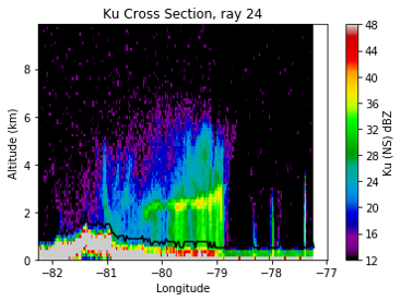
GPM's radar captured captured the reflectivities shown in this cross-section as it flew over the snow storm on February 20th, with snow and frozen precipitation shown in blue and purple and rain shown in green and yellow. The melting layer marks the transition from snow to rain and slopes upward 2-3 km from central NC to the coast. These raw reflectivity measurements can then be converted to snowfall and rainfall rates which are used to estimate how much precipitation fell during the storm.
NASA's GPM Core Observatory flew over the storm at 1:50pm ET (1850 UTC) on February 20th, capturing snowfall rates with its Dual-frequency Preciptation Radar (DPR). This overpass provided valuable data to the Investigation of Microphysics and Precipitation for Atlantic Coast-Threatening Snowstorms (IMPACTS) mission, because the NASA ER-2 aircraft, which carries instruments similar to GPM, was unable to fly due to strong winds at its takeoff location. However, the NASA P-3 aircraft was able to fly through the storm and collected detailed information about the quantity, size, and shape of snow particles at different levels in the atmosphere in addition to temperature, humidity, and wind information. This data will be used to learn more about the structure of snow bands in this and similar storms.
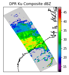
Composite reflectivity data collected by GPM's radar over the entire overflight path.