
Hurricane Barry Makes Landfall in Louisiana
UPDATE 7/17/19:
This GPM IMERG animation shows rainfall accumulations from #HurricaneBarry in the Gulf of Mexico from July 11-16, 2019. Learn more: https://t.co/1QjFLDbD0k pic.twitter.com/CC7J0AsSTW
— NASA Precipitation (@NASARain) July 17, 2019
This 6-day animation shows the heavy precipitation that Hurricane Barry (2019) producing from July 11 to 16 in the Gulf of Mexico and the South Central U.S. While forecasters were initially concerned that the largest accumulations would extend far over land, this animation shows that the largest accumulations remained mostly off shore. The precipitation estimates shown in this animation come from a near-realtime merging and calibration of observations made by the satellites of many nations. The IMERG algorithm, run at NASA Goddard, performs this data merging. The left side of the movie shows the total accumulation starting in the early hours of July 11, 2019, while the right side shows the accumulation during just the most recent 3-hour period.
Video Credit: Owen Kelley (NASA GSFC), Jacob Reed (Telophase / NASA GSFC)
UPDATE 7/16/19:
Barry became the first hurricane of the 2019 season just before making landfall on the south-central coast of Louisiana near Intracoastal City on Saturday the 13th of July 2019. The storm came ashore around 1 pm CDT (18:00 UTC) with sustained winds reported at 75 mph by the National Hurricane Center, making Barry a minimal Category 1 hurricane. The biggest threats posed by Barry were heavy rains and flooding due to the storm’s slow movement, close proximity to land, and time spent organizing over the warm waters of the Gulf of Mexico. Barry formed from an area of low pressure that originated over the Tennessee Valley from a thunderstorm complex, which then drifted southward through the Florida Panhandle, off of the coast and out over the northeastern Gulf of Mexico on the 10th of July. There it provided a focus for showers and thunderstorms, which led to its gradual intensification. Despite the warm waters of the Gulf, the system was slow to strengthen due to inhibiting northerly wind shear. Nevertheless, it became Tropical Storm Barry on the 11th at 10:00 am CDT about 95 miles SSE of the mouth of the Mississippi River at which time it was drifting slowly westward. Over the next day, Barry slowly intensified into a strong tropical storm as it continued to move west, but northerly wind shear and accompanying drier air caused Barry to remain rather asymmetrical with most of the heavier rain and thunderstorm activity located in the southern half of the storm. Fortunately, this precluded the storm from taking full advantage of the warm waters and quickly intensifying. It also meant that the heaviest rains stayed offshore. After drifting generally slowly westward to this point, Barry finally began to recurve to the NW on Saturday the 13th while gaining just enough intensity to become a hurricane before hitting the coast of Louisiana. As Barry moved further inland, it continued to recurve more towards the north and slowly increased its forward speed while weakening back to a tropical storm.
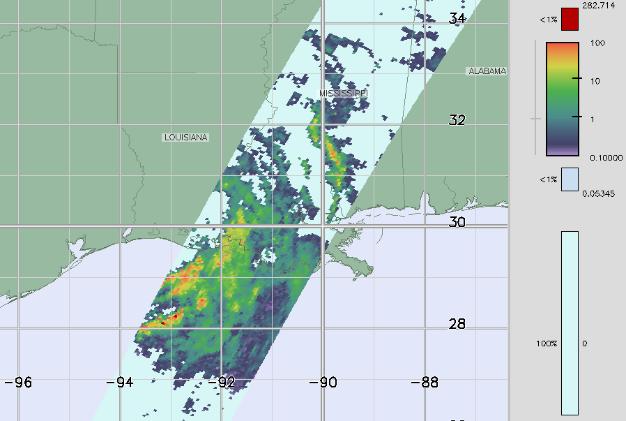
This image of Barry was captured by the GPM core satellite several hours after Barry had made landfall on the coast of Louisiana. The image shows instantaneous surface rain rates (mm/hr) derived from the Dual-polarization Radar onboard the GPM core satellite at 02:42 UTC 14 July 2019 (9:42 pm CDT 13 July 2019). In it, heavy rain bands are shown wrapping up around the eastern side of the storm’s center from the Gulf of Mexico and into central Louisiana and Mississippi. Some of the storm’s asymmetry is also revealed by the fact that the rain shield is much heavier and broader south of the center of circulation. At the time of this image, the center of Barry was located about 35 miles SW of Alexandria, Louisiana and had maximum sustained winds of 50 mph. The following day on the 14th, Barry continued its northward trek into northwestern Louisiana and weakened to a tropical depression before continuing on into Arkansas. Despite numerous power outages and localized flooding, there have been no reports of fatalities or serious injuries due to Barry.
Image and Text by Steve Lang (SSAI / NASA GSFC)