

Hurricane Hanna Brings Heavy Rains to Parts of South Texas
Hanna formed from a westward propagating tropical easterly wave that entered the southeast corner of the Gulf of Mexico on Tuesday July 21st. The wave provided a focus for shower and thunderstorm activity, which then led to the formation of an area of low pressure over the central Gulf of Mexico. The National Hurricane Center (NHC) found that this low had developed a closed circulation by the evening of Wednesday July 22nd, making it Tropical Depression #8. Over the next 24 hours, the depression slowly organized and intensified over the central Gulf before reaching tropical storm intensity on the evening of the 23rd, becoming Tropical Storm Hanna, the earliest 8th named storm of the Atlantic season on record. A subtropical ridge to the north kept Hanna moving in a mainly westward direction towards the south Texas coastline. On Friday the 24th, Hanna continued to show signs of intensifying but remained at tropical storm intensity. On the morning of Saturday, the 25th, NHC found that Hanna had reached hurricane intensity, the first of the season. At this point, the storm was centered about 100 miles ESE of Corpus Christi, TX and still moving west. Hanna was still in the process of strengthening when it made landfall later that day around 5 pm (CDT) over Padre Island as a strong category 1 storm with sustained winds reported at 90 mph by NHC.
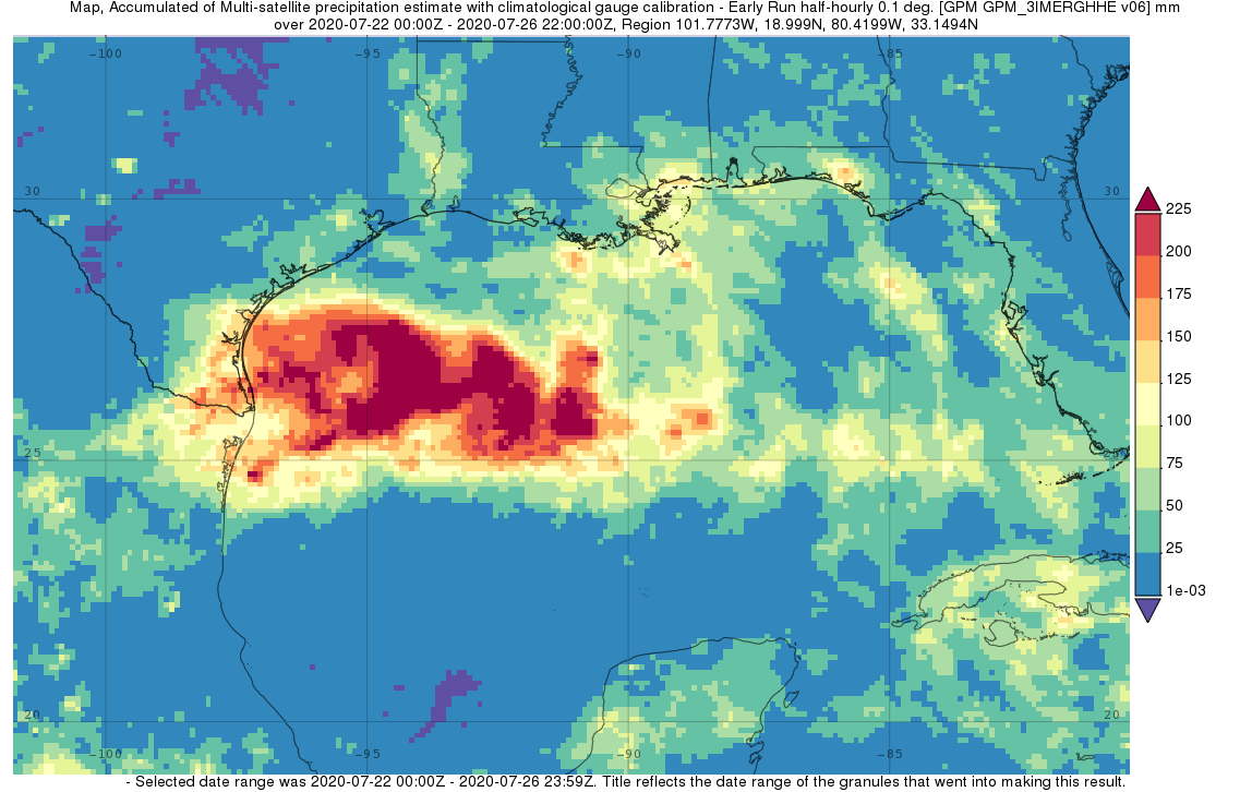
Surface rainfall accumulations (mm) estimated from the NASA IMERG satellite precipitation product from 00 UTC 22 to 00 UTC 27 July 2020 in association with the formation and passage of Hurricane Hanna. Image from NASA GSFC using IMERG data archived at https://giovanni.gsfc.nasa.gov/giovanni/. This image was produced with the Giovanni online data system, developed and maintained by the NASA GES DISC.
IMERG surface rainfall accumulations are shown here for the period 22 to 26 July 2020 for the central and northern Gulf of Mexico and the adjacent coastal regions. The heaviest rainfall totals, in excess of 225 mm (~9 inches, shown in dark red) are located offshore over the northwestern Gulf of Mexico. Over land, the highest rainfall amounts occur along the southern coast and southern tip of Texas where between 100 mm (~4 inches, shown in yellow) to as much as 200 mm (~8 inches, shown red) of rain are estimated to have fallen. In addition to the heavy rain over south Texas, Hanna’s onshore flow brought coastal flooding to many parts of the south Texas coast, while Hanna’s outer rainbands also brought localized areas of heavy rain to portions of the northern Gulf Coast.
This animation shows IMERG rain rates (blue-yellow shading) and accumulations (green shading) observed from July 22-26, 2020 along Hurricane Hanna’s track as it crossed the Gulf of Mexico and reached southern Texas and northeastern Mexico. The National Hurricane Center began tracking the tropical depression that would become Hanna on July 23, shown here as a red line, smoothed in time. Hanna continued to strengthen into a Category 1 hurricane with a clearly visible eye on July 25 when it made landfall in southern Texas at 22:00 UTC. During Hanna’s approach, IMERG observed rain rates in excess of 25 millimeters/hour (~1 inch/hour; yellow shading). Accumulations during Hanna’s passage exceeded 20 centimeters (~8 inches; dark green shading) in parts of southern Texas and northeastern Mexico.
Story and image by Steve Lang (NASA GSFC)
Animation and caption by Jason West (NASA GSFC)