
IMERG Observes Additional Plum Rains in East Asia
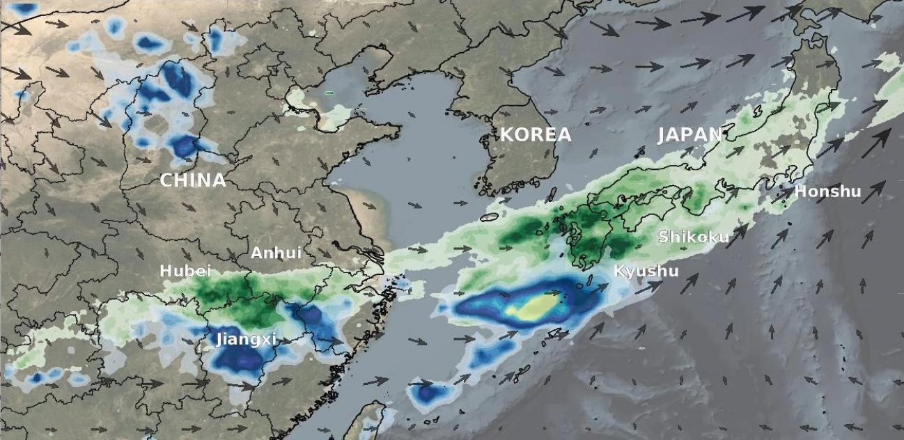
From July 3-9, 2020, NASA’s IMERG algorithm continued to observe the heavy precipitation that fell as part of the seasonal Meiyu-Baiu rains (“plum rains”) in east Asia. Weekly totals reached their regional maxima over the island of Kyushu in southern Japan. About half of the island of Kyushu received over 45 cm (~18 inches) of rain. The majority of Honshu, Japan’s main island, as well as Shikoku to its south, were also impacted by the rains, receiving from 10-25 cm, depending on the location. Additionally, large areas of eastern China were also covered by the plum rains during this weekly period, with some parts exceeding 45 cm of accumulation. Reports of flooding and landslides throughout the region continued to appear in the media throughout the period of these observations, including (in Japan) on Kyushu and central Honshu, and in China’s Anhui, Hubei, and Jiangxi provinces.
Why do the Meiyu-Baiu rains form such a distinctive southwest-to-northeast arc? To help answer that question, we overlay the mid-atmosphere (500 mb, roughly corresponding to 18,000 ft high) winds computed by NOAA’s GFS model analysis and smoothed here to half-hourly time steps. The largest arrows here correspond to ~35 meters/second (almost 80 miles per hour). 500 mb winds are frequently referred to by meteorologists and climate scientists to help diagnose the location of convection and rainfall. Note the strong west-to-east jet that lines up with the rain bands throughout most of the animation. This jet has been shown to drive warm air from the Asian continent eastward, where it then helps to lift the warm, moist air near the coast, leading to precipitation. The 500 mb winds also help to ‘steer’ weather disturbances into the region, further contributing to convection and rainfall.
Learn more about the Meiyu-Baiu ("plum rains") weather pattern:
- http://iprc.soest.hawaii.edu/newsletters/newsletter_sections/iprc_climate_vol9_2/jet_stream_meiyu_baiu.pdf
- https://journals.ametsoc.org/jcli/article/23/1/113/32279
Visualization & Text by Jason West (NASA GSFC)