Karachi Pakistan Sees a Year's Worth of Rainfall in a Week
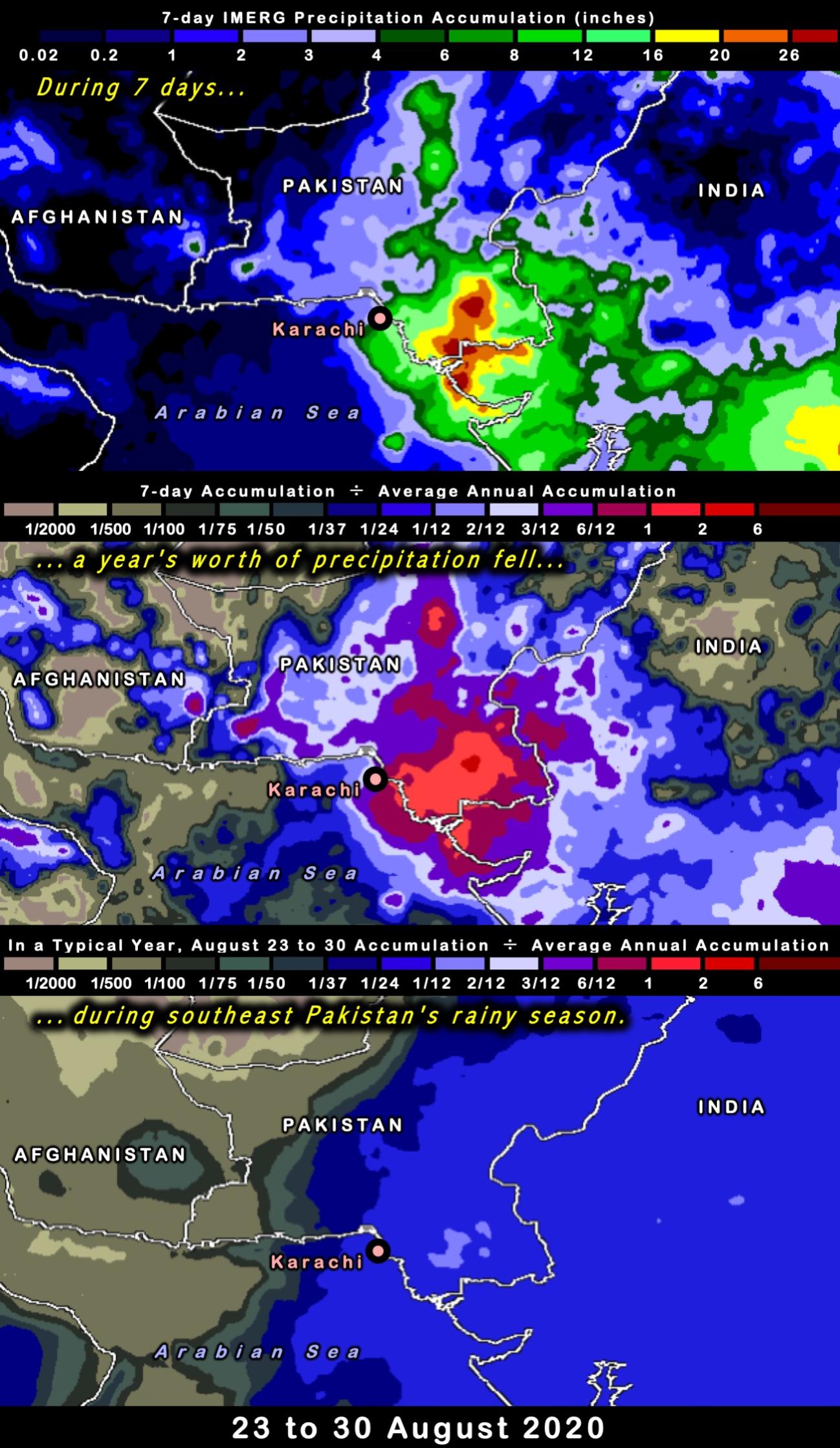
In the last week of August 2020, Pakistan's largest city, Karachi, received over 8 inches of rainfall according to NASA's IMERG dataset, causing destructive flooding in the region. The amount of rain that fell that week is roughly equivalent to the amount that Karachi typically receives in an entire year, based on IMERG's 19-year global climatology. In a typical year, most of Karachi's rain will fall in July and August, but the rainfall during the week of August 23rd was unusually heavy.
The top panel of the three panels in this image shows the depth of the 7-day rainfall accumulation in inches (August 23 to 30, 2020). The light green color indicates at least 8 inches of rainfall in Karachi and locations further inland and to the east.
The middle panel divides the rain that fell during this seven day period by the average annual accumulation at each 0.1x0.1 degree grid box of the IMERG product. Values in excess of 1 (red) indicate locations where a full year's worth of rain fell in this one-week period. When such an extreme event occurs, it can be difficult for the built environment to function normally.
The bottom panel gives a sense of what is normal for the last week of August. It shows what fraction of the annual total precipitation falls during the last week of August of a typical year. Regions where at least 1/24 of a "year's worth" of rain typically falls during the last week of August normally experience part of their rainy season during the last week of August. This is the case for the eastern portion of Pakistan and India. Regions where less than 1/100 of a "year's worth" of rain typically falls in the last week of August normally experience part of their dry season during the last week of August. This is the case for western Pakistan and Afghanistan.
IMERG rainfall estimates are automatically generated in near real-time as part of NASA's effort to monitor the Earth. The estimates are based on observations from an international constellation of satellites lead by the GPM Core Observatory. Several months after an event occurs, the rainfall estimates are improved when NASA re-runs the IMERG algorithm using additional data sets that are not available in near-realtime.
Credits:
Imagery by Owen Kelley, Jason West (NASA GSFC)
Text by Owen Kelley, Jason West, Jacob Reed.(NASA GSFC)


