
NASA Reveals Heavy Rainfall in Tropical Cyclone Fani
Satellite data revealed heavy rainfall in powerful Tropical Cyclone Fani before it made landfall in northeastern India. Fani brought that soaking rain to the region and continues to drop heavy rainfall on May 3, as it moves toward Bangladesh.

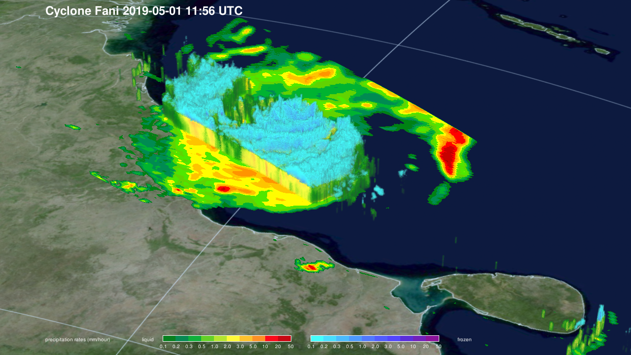
NASA’s GPM or Global Precipitation Measurement mission satellite provides information on precipitation from its orbit in space. On May 1 at 7:56 a.m. EDT (1156 UTC), the GPM Core Observatory captured an overpass of the powerful storm as it continued strengthening and moving toward landfall. A 3D image and a color-enhanced rainfall image were created at NASA’s Goddard Space Flight Center in Greenbelt, Maryland. The images showed how high thunderstorms stretched into the troposphere and measured rainfall rates. GPM found that some of the heaviest rainfall rates were up to 50 millimeters (2 inches) per hour and were in the western quadrant of the storm.
GPM is a joint mission between NASA and the Japan Aerospace Exploration Agency or JAXA. GPM also utilizes a constellation of other satellites to provide a global analysis of precipitation of rainfall around the world.
The India Meteorological Department reported that Fani made landfall in Odisha at about 8 a.m. local time on Friday morning, May 3. Fani’s sustained winds were estimated near 108 knots (125 mph/201 kph) at the time of landfall. Fani is the strongest cyclone to hit India’s coast since a storm in 1999. About 1.2 million people had evacuated prior to Fani’s landfall.
The Joint Typhoon Warning Center or JTWC issued their final warning on Fani at 11 a.m. EDT (1500 UTC) on May 3. At that time, Fani’s center was located near 21.8 degrees north latitude and 86.6 degrees east longitude. It was centered about 145 nautical miles west-southwest of Kolkata, India. Fani has tracked north-northeastward. At that time, Fani’s maximum sustained winds had dropped to 70 knots (80 mph/130) making it the equivalent of a Category 1 hurricane on the Saffir-Simpson Hurricane Wind Scale.
On May 3, NASA infrared satellite imagery measured the temperatures of the cloud tops of the thunderstorms that made up Fani. The imagery showed warming cloud tops and significantly reduced deep convection (rising air that forms the thunderstorms that make up a tropical cyclone).
The JTWC noted that Fani is weakening due to land interaction. Fani is expected to reach Bangladesh as a minimal tropical storm early on May 4, and dissipate later in the day.
Images produced by Jacob Reed (Telophase/NASA GSFC) and text by Rob Gutro (NASA GSFC)