
IPHEx Demonstrates Two New Instruments
Three Radars are Better than One
Putting three radars on a plane to measure rainfall may seem like overkill. But for the Integrated Precipitation and Hydrology Experiment field campaign in North Carolina recently, more definitely was better.
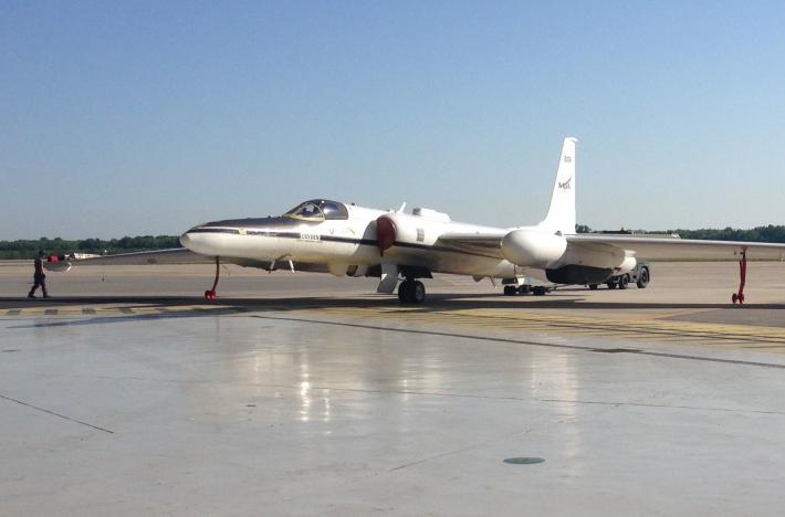 During the field campaign, NASA's ER-2 research aircraft flew out of Robins Air Force Base in Georgia. HIWRAP is under the wing in the black compartment; the Cloud Radar System is under the other wing and is not visible; and the EXRAD radar is in the extended nose cone.
Image Credit: NASA / Gerry Heymsfield
The three instruments, developed by the High Altitude Radar group at NASA's Goddard Space Flight Center in Greenbelt, Maryland, flew as part of the Global Precipitation Measurement (GPM) mission’s six-week ground-validation program that took place May 1 through June 15 in the southern Appalachians, specifically to measure rain in difficult-to-forecast mountain regions. In addition to validating measurements, the campaign tested data-processing algorithms made by the GPM Core Observatory, launched in February.
The campaign represented a first for NASA. Never before has the agency flown more than two radar systems, tuned to different frequencies, to measure rainfall in the field. In addition, two of the instruments were making their maiden flight to demonstrate technological improvements that may pave the way for future high-performance airborne or space-borne precipitation radars for studying storms.
Future precipitation missions and, more particularly, the Aerosol Clouds Ecology, or ACE, mission, which the National Research Council recommended in its Earth Science Decadal Survey, have made the development of new radar systems to observe clouds and light precipitation a priority.
Why Radar and Why Three?
The decision to fly three different systems was far from overkill, according to campaign scientists.
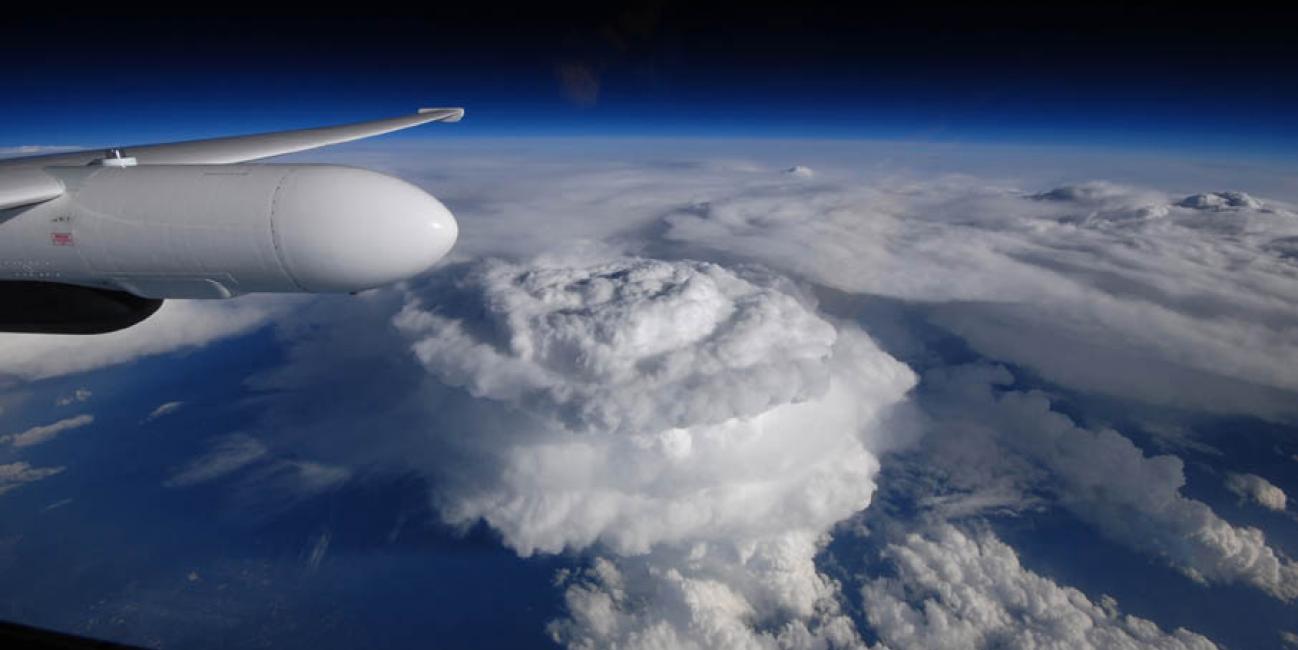
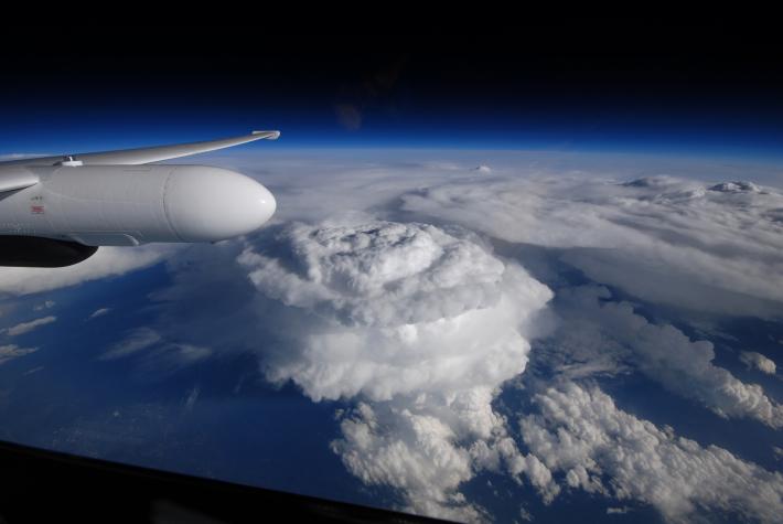 This image shows severe thunderstorms over South Carolina as observed from NASA’s ER-2 aircraft flying at 65,000 feet during the Integrated Precipitation and Hydrology Experiment recently.
Image Credit: NASA
Rainfall comes in more than 31 flavors, from tiny cloud droplets and misty drizzle, to fat raindrops and two-inch hailstones, and, of course, everything in between. Different radar frequencies pick up different precipitation types, generally based on size and whether the particles are ice or liquid. Radars flying with multiple frequencies can study more precipitation types and identify where they occur inside clouds, giving scientists a more complete picture of the inner workings of a rainstorm.
In particular, lower-microwave frequencies can detect heavy rain all the way to the ground. But tiny cloud particles require a higher-microwave frequency signal to detect them. Because that signal sometimes gets attenuated before it makes it all the way through the cloud and back to the radar, precipitation radars traditionally require a large, high-powered antenna.
What's Old is New Again
Enter the Cloud Radar System, a 20-year-old radar that has been completely rebuilt from the inside out, said Gerry Heymsfield of Goddard's High Altitude Radar group, which revamped the instrument. “The old one was a good radar,” Heymsfield said, “but the big difference in the new one is we’re using a solid-state transmitter.” The new transmitter, which sends the radar pulse, requires less power, occupies less space, and returns more reliable results — advances that make a radar system more suitable for aircraft and satellites.
The Cloud Radar System also sports a new antenna for receiving the data-laden return signals, or backscatter, of the radar pulse. Partners at Northrup Grumman designed the new antenna, led by Goddard Principal Investigator Paul Racette, and the result is a scaled down, proof-of-concept of what may one day fly in space, Heymsfield said.
The Cloud Radar System design grew out of a similar approach the High Altitude Radar group used to build the two other radars that measured rainfall during the campaign: the High-altitude Wind and Rain Profiler (HIWRAP), and the ER-2 X-Band Radar (EXRAD).
Satellite Simulator
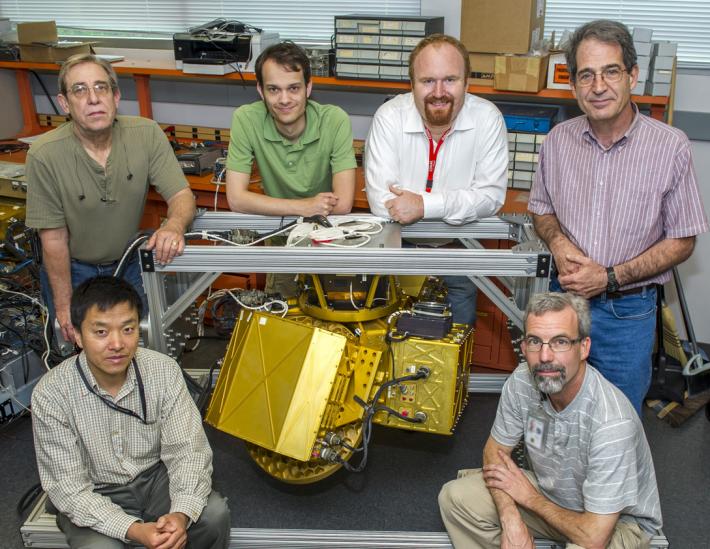 HIWRAP was developed by Goddard’s High Altitude Radar Group. The team includes (left to right): Lihua Li, Gerry McIntire, Michael Coon, Matthew McLinden, Gerry Heymsfield and Martin Perrine. McLinden led the work on the Cloud Radar System and Li led the work on EXRAD.
Image Credit: NASA Goddard / Bill Hrybyk
During the field campaign in North Carolina, all three radars flew at an altitude of 65,000 feet on NASA’s ER-2 aircraft, managed by Armstrong Flight Research Center in Edwards, California. Beneath the ER-2, a second plane, managed by the University of North Carolina, flew through clouds to collect data on the details of the precipitation and cloud particles. On the surface, NASA's GPM team worked with NOAA's Hydrometeorological Test Bed and Duke University to capture precipitation as it hit the ground, using ground-based radar that scanned the air between the surface and the rainclouds and a network of rain gauges throughout the mountains and valleys.
During the six-week field campaign, HIWRAP — one of several instruments also used on NASA’s Hurricane and Severe Storm Sentinel mission flying later this summer and fall — stood in for the GPM satellite. Its two radar frequencies, 35 gigahertz for light rain and 13.5 gigahertz for heavy rain, are nearly identical to the GPM Core Observatory's Dual-frequency Precipitation Radar. Scientists collected the data, which they now will process with computer algorithms specifically designed to convert radar-retrieval data into rain estimates. They then will compare those estimates with the ground data to determine whether they need to fine-tune the algorithms, Heymsfield said.
EXRAD, like the retooled Cloud Radar System, made its flight debut during the campaign. It complemented HIWRAP by gathering data in the 10-gigahertz frequency band ideal for measuring big raindrops and hail in thunderstorms. Unlike the other radars that just point down, EXRAD also has a scanning capability to capture rainfall over a wider field of view below.
Unique Capability
Multiple radars with multiple frequencies looking at the same storm provided the science team with a unique capability, Heymsfield said. As the ER-2 flew overhead, the radars and other instruments captured how the range of cloud droplets, raindrops, and ice pellets moved and changed relative to one another over time. Those observations get at the heart of how storm systems behave, which in turn will lead to better models used for weather and flood forecasting, Heymsfield said.
“When you look at different clouds with different frequencies, it tells a lot about the cloud particles that are in there,” said Heymsfield. “Having four frequencies on the ER-2 allowed us to measure a much broader range of cloud and precipitation that will help both GPM and future cloud and precipitation missions.”
Related Links