Africa

Maps showing the Average Precipitation Rate in Lake Victoria, Africa - Day vs. Night
Lake Victoria is the largest lake in Africa and an economic and food security lifeline for roughly 30 million people living near its shores in Uganda, Kenya, and Tanzania. But it also takes lives. Cyclical, daily weather patterns around the lake create violent nighttime thunderstorms that kill roughly 3,000 to 5,000 fishermen per year. “This is definitely one of the stormiest places on Earth,” said Wim Thiery, a climate scientist at the Vrije Universiteit Brussel who has studied Lake Victoria for several years. “Almost every night, you see these intense thunderstorms and sometimes even water

NASA's IMERG Shows Devastating Rainfall Over East Africa

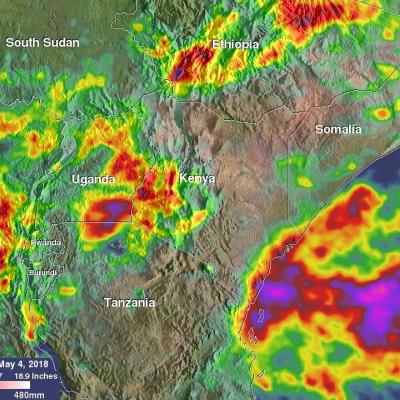
Heavy seasonal rainfall has recently caused flooding in Kenya resulting in displacement of over 244,000. This deluge follows the severe drought that afflicted East Africa in 2017. The estimated death toll from flooding and mudslides has recently been increased to about 100 people. Rainfall accumulation estimates from NASA's Integrated Multi-satellitE Retrievals for GPM (IMERG) data are shown here for the period from April 27 to early May 4, 2018. During this period heavy seasonal precipitation fell over Kenya. Rainfall totals in some areas near the Indian Ocean coast were estimated by IMERG to

GPM Sees Fred Forming In Cape Verdes

Fred became the first Cape Verdes hurricane of the 2015 Atlantic season when it was upgraded from a tropical storm on August 31, 2015 at 0600 UTC (2 AM AST). The GPM core observatory satellite flew over on August 30, 2015 at 0236 UTC when Fred was forming from a tropical wave that moved off the African coast. Rainfall was measured by GPM's Dual-Frequency Precipitation Radar (DPR) at the extreme rate of close to 128 mm (5.0 inches) per hour. Rainfall in towering convective thunderstorms at Fred’s center of circulation were providing the energy necessary for intensification into a hurricane
NASA satellites used to predict zebra migrations
Of stars and stripes: NASA satellites used to predict zebra migrations One of the world's longest migrations of zebras occurs in the African nation of Botswana, but predicting when and where zebras will move has not been possible until now. Using NASA rain and vegetation data, researchers can track when and where arid lands begin to green, and for the first time anticipate if zebras will make the trek or, if the animals find poor conditions en route, understand why they will turn back. Covering an area of approximately 8,500 square miles (22,000 square kilometers), Botswana’s Okavango Delta is...

NASA Satellites Track Zebra Crossing

Submitted by JacobAdmin on Fri, 08/16/2013
Video Embed
Botswana's Okavango Delta and the Makgadikgadi Salt Pans are two ends of a 360-mile round trip zebra migration, the second longest on Earth. In this animation, shades of red show dry areas, green represents vegetation, and the dots show GPS tracked zebras. The zebras begin at the Okavango Delta in late September. After the dry Southern hemisphere winter, November rains signal it is time to begin their two-week journey to the Salt Pans.