
TRMM Sees Tropical Storm Bofa
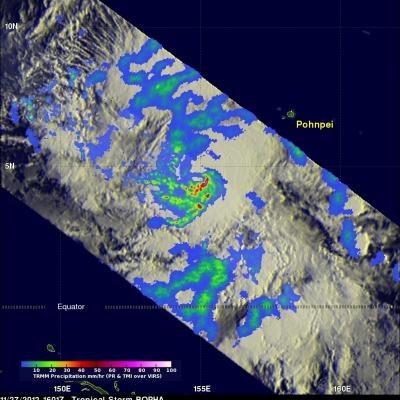
The TRMM satellite flew above tropical storm Bofa on November 27, 2012 at 1601 UTC and collected data used in the image above. TRMM showed that tropical storm Bofa had an area of very intense convective storms near the center of circulation. TRMM's Microwave Imager (TMI) and Precipitation Radar (PR) data revealed that rain was falling at a rate of over 70mm/hr (~1.75 inches) in that area. TRMM's Precipitation Radar (PR) also showed that powerful storms in the area of the developing eye wall were reaching to heights of about 17km (~10.6 miles). Click here to see a simulated flyby above Bofa