
GPM Satellite Probes Dangerous Category Five Hurricane Irma
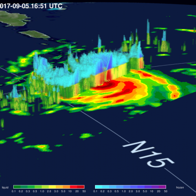
The GPM core observatory satellite had an exceptional view of hurricane Irma's eye when it flew above on September 5, 2017 at 12:52 PM AST (1652 UTC). This image shows a rainfall analysis that was derived from GPM's Microwave Imager (GMI) and Dual-Frequency Precipitation Radar (DPR) data. Irma was approaching the Leeward Islands with maximum sustained winds of about 178 mph (155 kts). This made Irma a dangerous category five hurricane on the Saffir-Simpson hurricane wind scale. Intense rainfall is shown within Irma's nearly circular eye. GPM's DPR (shown in lighter shades) uncloaked