eastern Pacific

Tropical Storm Javier Forms In The Eastern Pacific

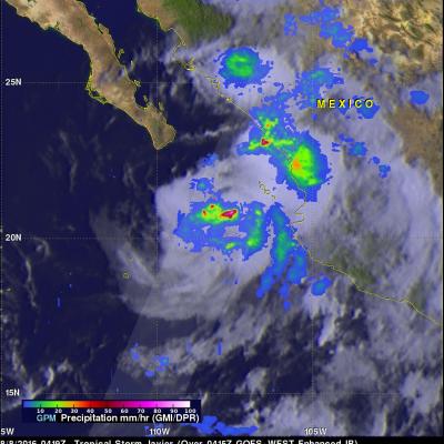
Tropical storm Javier formed on August 7, 2016 in the Eastern Pacific Ocean off Mexico's western coast. Javier formed partially from the remnants of Hurricane Earl. Landslides caused by heavy rainfall from Hurricane Earl caused the reported deaths of at least 39 people in eastern Mexico. The GPM core observatory satellite flew above tropical storm Javier on August 8, 2016 at 0419 UTC. Rainfall was analyzed using GPM's Microwave Imager (GMI) and Dual-Frequency Precipitation Radar (DPR) instruments. Those data showed that Javier was producing heavy rainfall both near the center of the tropical

Eastern Pacific Tropical Cyclone Forming

The eastern Pacific Ocean has become active on cue with the start of the hurricane season in that area. Only a few days after hurricane Amanda weakened and disappeared the National Hurricane Center (NHC) says that development of another tropical cyclone is probable southeast of Salina Cruz, Mexico. The image above shows rainfall data captured by the TRMM satellite as it flew over on June 2, 2014 at 0659 UTC. TRMM's Microwave Imager (TMI) and Precipitation Radar (PR) data are shown overlaid on an enhanced infrared image from the GOES-EAST satellite received at 0645 UTC. TRMM found areas of

Possible Eastern Pacific Tropical Cyclone Formation

The Eastern Pacific hurricane season began on May 15, 2014 and today a potential tropical cyclone is forming south-southwest of Manzanillo, Mexico. The TRMM satellite collected data as it flew above this area on May 21, 2014 at 2259 UTC. TRMM's Precipitation Radar (PR) found rain falling at over 102.5 mm/hr (about 4 inches) in some convective showers and thunderstorms in this area. A GOES-WEST image was overlaid with a rainfall analysis from TRMM PR and TMI. TRMM's Precipitation Radar (PR) data were used to show a 3-D view of the rainfall structure in this disturbed weather. A few strong