Flossie

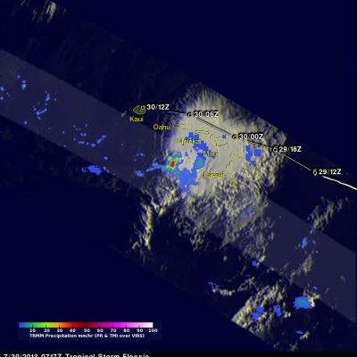
Hawaii Says Aloha To Flossie

The TRMM satellite had an excellent day time view of dissipating tropical depression Flossie as it was moving to the northwest of the Hawaiian Islands on July 30, 2013 at 2348 UTC (1:38 PM HAST). An analysis of rainfall from TRMM's Microwave Imager (TMI) and Precipitation Radar (PR) is shown overlaid on a combination visible and infrared image from TRMM's Visible and InfraRed Scanner (VIRS) instrument. This analysis shows that very little precipitation was then occurring near the center of the weakening tropical cyclone's circulation. The most intense rain was found by TRMM to be falling at a

Weakening Tropical Storm Flossie Hits Hawaiian Islands

Weakening tropical storm Flossie had lightning with heavy rain and winds as it drove through the Hawaiian islands. The TRMM satellite flew above tropical depression Flossie on July 30, 2013 at 0717 UTC (July 29, 2013 at 9:17 PM HAST). TRMM's Microwave Imager (TMI) and Precipitation Radar (PR) instruments showed that the heaviest rain at that time was located to the southwest of the Islands and was falling at a rate of over 88mm/hr (3.5 inches). Flossie's approximate locations with appropriate tropical cyclone symbols are shown overlaid in white. TRMM's Precipitation Radar is able to separate

Tropical Storm Flossie Threatens Hawaiian Islands

The TRMM satellite had a very good view of tropical storm Flossie in the eastern Pacific Ocean on July 28, 2013 at 0734 UTC. The image on the left shows an analysis of rainfall data from that pass using TRMM's Microwave Imager (TMI) and Precipitation Radar (PR) instruments. TRMM PR data found rain falling at a rate of over 46 mm/hr (~1.8 inches) in storms just south of Flossie's center of circulation. TRMM PR also found that some of these storms were returning 45dBZ reflectivity values to the satellite indicating that moderate to heavy rain was falling in that area. The map on the right shows