hurricane

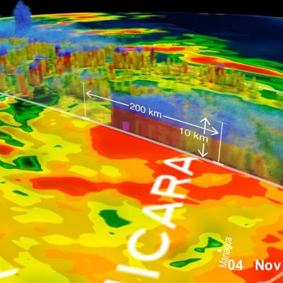
GPM Eta Screenshot
The Global Precipitation Measurement (GPM) Core Observatory satellite flew over Hurricane Eta at 11:41 p.m. CT on Tuesday, Nov. 3 (0541 UTC Wednesday, Nov. 4). GPM observed the storm’s rainfall with its two unique science instruments: the GPM Microwave Imager ( GMI ) and Dual-frequency Precipitation Radar ( DPR ). As the visualization shows, the instruments observed a large swath of heavy precipitation extending to the north and east of the hurricane’s center, which matched earlier forecasts that called for particularly heavy rainfall across the storm’s path. These two- and three-dimensional

Hurricane Henriette

The TRMM satellite flew over the eastern Pacific Ocean on August 6, 2013 0233 UTC (~5:33 PM local time) collecting data for the low sun angle views of hurricane Henriette shown here. The Visible/Infrared image on the left shows the shadows cast by towering thunderstorms on the northeastern side of Henriette's forming eye wall. The image on the right shows the same image with rainfall derived from TRMM's Microwave Imager (TMI) and Precipitation Radar (PR) instruments overlaid. TRMM's PR instrument measured rain falling at the rate of over 55.46mm/hr (~2.2 inches) per hour in this towering