Keila

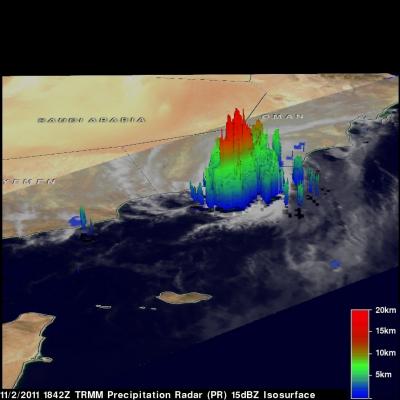
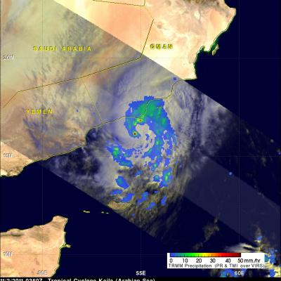
TRMM Views Deadly Storm

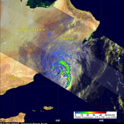
Tropical storm Kelia caused the reported deaths of at least 11 people when it came ashore in Oman on Thursday 3 November 2011. TRMM's Microwave Imager (TMI) had a good early morning view of Keila on 3 November 2011 at 0254 UTC. The TMI rainfall analysis from these data was overlaid on a sunlit visible and infrared image from TRMM's Visible and InfraRed Scanner (VIRS). This rainfall analysis shows a large band of moderate to heavy rainfall wrapping around the eastern side of the storm and drenching coastal Oman.
TRMM Sees Weakening Tropical Storm Keila JacobAdmin Thu, 11/03/2011
The TRMM satellite again flew over tropical storm Keila in the Arabian Sea on November 2, 2011 at 1842 UTC. Data received with that orbit shows that although Keila was weakening it was still producing some very powerful storms off the coast of Oman. A rainfall analysis from TRMM's Microwave Imager (TMI) and Precipitation Radar (PR) indicates that these storms were dropping rain at a rate of over 50mm/hr (~2 inches). TRMM PR data were used in the image above to show the 3-D vertical structure of those storms. Some extremely powerful storms in the band of rainfall off the coast of Oman were
Tropical Storm Keila In The Arabian Sea JacobAdmin Wed, 11/02/2011
The TRMM satellite passed directly above a recently formed tropical cyclone in the Arabian Sea on November 2, 2011 at 0350 UTC. An analysis of rainfall from TRMM's Microwave Imager (TMI) and Precipitation Radar (PR) instruments is shown in the image on the upper left. TRMM data shows that rainfall rates with tropical storm Keila ranged from light to moderate along the south-eastern coast of Oman. Moderate to heavy rainfall was revealed to be spiraling into Keila's center of circulation in the Arabian Sea near the southeastern coast of Oman. The image above is a rendering that shows Keila's