Mekkhala

Mekkhala Becomes A Typhoon, Drenches The Philippines

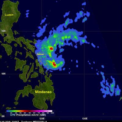
On January 16, 2015 tropical storm Mekkhala became the first western Pacific typhoon of the year just before hitting the eastern Philippines. This image shows rainfall derived from data captured by the GPM (core satellite) on January 16, 2015 at 2200 UTC. This was only about four hours after Mekkhala was upgraded to a typhoon. GPM's Microwave Imager (GMI) found rain falling at a rate of over 70.7 mm (about 2.8 inches) per hour in storms southwest of the typhoon's eye. Rainfall over the Philippines, enhanced by typhoon Mekkhala, was analyzed using near real time merged satellite data (3B42)

Tropical Depression Mekkhala Organizes

Tropical Depression 01W, in the western Pacific Ocean, has been given the name Mekkhala. The tropical cyclone has become much better organized and the Joint Typhoon Warning Center (JTWC) predicts that tropical storm Mekkhala will affect the eastern Philippines in a few days. The GPM (core satellite) flew above Mekkhala on January 14, 2015 at 1043 UTC. GPM's Microwave Imager (GMI) instrument observed rain falling at a rate of over 71.63 mm (about 2.8 inches) per hour in intense convective storms near the tropical cyclone's center. This 3-D view was derived from data collected by GPM's Radar (Ku

Two Satellites Measured Rainfall in Tropical Depression Mekkhala

The first tropical depression of the 2015 western Pacific season formed southwest of Guam on January 13 and is predicted to intensify into a tropical storm while headed toward the Philippines. NASA's TRMM and GPM satellites provided a look at Tropical Depression Mekkhala's rainfall data that showed the area of moderate rainfall had expanded as the storm strengthened on January 13. Mekkhala was previously known as Tropical Depression 01W until January 14 when it was renamed. Both the Global Precipitation Measurement (GPM) core satellite and the Tropical Rainfall Measuring Mission (TRMM)