
Songda becomes a Super Typhoon
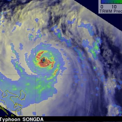
As predicted, Typhoon Songda intensified and was a super typhoon with wind speeds estimated at over 130 kts ( ~145 mph) when the TRMM satellite passed directly over head on 26 May 2011 at 0806 UTC. The image above used data from TRMM's Visible and InfraRed Scanner (VIRS) and a TRMM rainfall analysis . The rainfall analysis from TRMM's Microwave Imager (TMI) and Precipitation Radar (PR) data shows that Songda had a circular eye with extremely heavy rainfall, particularly in the southeast quadrant. TRMM's PR data shows the concentric rain bands typical of powerful typhoons. Below is a simulated