
TRMM Sees Severe Weather
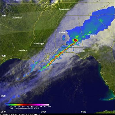
The TRMM satellite flew over the southeastern United States on April 7, 2014 at 1300 UTC (9:00 AM EDT) when a line of intense thunderstorms was moving through the area. Tornado watches were in effect over much of the area. A possible tornado, associated with the same weather system, caused destruction and injuries when it moved through southern Mississippi earlier at about 2 AM EDT. TRMM's Precipitation Radar (PR) data revealed that rain was falling at a rate of over 130mm/hr (about 5.1 inches) in one severe thunderstorm near the Alabama and Florida panhandle border. A radar reflectivity value