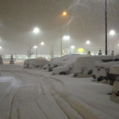
Over the weekend, GCPEx had its first large lake effect snow, which put 2 inches down at the CARE site. Chris Kidd, Operations Scientist for GCPEx this week, said in an email, "We were feeling rather poorly done-by at CARE due to the lack of snow there. However, we cheered up as we got back to Barrie [12 miles up the road where the GCPEx team is staying]. About 12+ inches here!" Parking lot at the GCPEx team's hotel in Barrie, Ontario. They were very excited to be buried in a foot of snow. Credit: NASA / Chris Kidd Lake effect snow forms when cold winds pick up moisture and energy as they pass
In the CARE operations trailer monitoring weather conditions during the DC-8 flights on 6 February 2012 at approximately 9pm EST. Gail Skofronick-Jackson is the Deputy Project Scientist for GPM at Goddard Space Flight Center in Greenbelt, Md. She specializes in the remote sensing of snow, and is currently the mission scientist for the campaign at the CARE ground site in Ontario, Canada. She writes to us about a night flight on February 6 and the snow that didn't show. Models showed quickly developing snow from 9-10pm EST tonight (6 Feb 2012). We are at 9:22 and we don't yet see snow in the
Joe Munchak is a scientist at Goddard Space Flight Center who specializes in remote sensing of snow. This week he is at the CARE site in Ontario as one of the operations scientists for the GCPEx ground validation. It’s been a relatively eventful few days here in Barrie, Ontario, with two coordinated air-ground campaigns over the past three days. I was actually driving to Barrie from my home in Maryland during the first event (January 28th), and got to experience some lake effect snow bands first-hand in northern Pennsylvania on my way up. These were very narrow, only a few miles wide, but
By Ellen Gray, NASA Goddard Space Flight Center Original www.nasa.gov Feature (published 1/31/12) Predicting the future is always a tricky business -- just watch a TV weather report. Weather forecasts have come a long way, but almost every season there's a snowstorm that seems to come out of nowhere, or one that's forecast as 'the big one' that turns out to be a total bust. In the last ten years, scientists have shown that it is possible to detect falling snow and measure surface snowpack information from the vantage point of space. But there remains much that is unknown about the fluffy white...