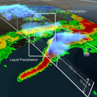
snowstorm

3D Views of February Snow Storms from GPM
Download this video in HD formats from NASA Goddard's Scientific Visualization Studio The Global Precipitation Measurement (GPM) Core Observatory captured a 3-D image of a winter storm on Feb. 17, 2015, that left 6 to 12 inches of snow over much of Kentucky, southwestern West Virginia and northwestern North Carolina. The shades of blue indicate rates of snowfall, with more intense snowfall shown in darker blue. Intense rainfall is shown in red. The imagery shows great variation in precipitation types over the southeastern United States. Download this video in HD formats from NASA Goddard's...
GPM Data from a March 2014 Snostorm
Image Credit: NASA's Goddard Space Flight Center Download this video in HD formats from NASA Goddard's Scientific Visualization Studio The most accurate and comprehensive collection of rain, snowfall and other types of precipitation data ever assembled now is available to the public. This new resource for climate studies, weather forecasting, and other applications is based on observations by the Global Precipitation Measurement (GPM) Core Observatory, a joint mission of NASA and the Japan Aerospace Exploration Agency (JAXA), with contributions from a constellation of international partner...

Precipitation Measured from U.S. Winter Storm

Freezing rain and snow from a winter storm have caused power outages and deaths from the southeastern to the northeastern United States. The TRMM-based, near-real time Multi-satellite Precipitation Analysis (TMPA) at the NASA Goddard Space Flight Center is used to estimate precipitation for much of the globe. TMPA (liquid) precipitation totals (mm) are shown for the week from February 7-14, 2014 when a winter storm was moving through the area. Snow depths can be expected to be 10 to 12 times that for the same amount of rainfall. Liquid precipitation estimates of over 110mm (~4.3 inches) are