Alberto Makes Landfall, Brings Heavy Rains to Parts of the Southeast and Tennessee Valley
Alberto formed out of a broad area of low pressure at the surface that was located over and around the Yucatan Peninsula. Because the area of low pressure was under the influence of a nearby upper-level trough, Alberto was designated as a subtropical storm by the National Hurricane Center (NHC) on the morning of Friday May 25th, which is rather unusual as most subtropical storms form at higher latitudes. The storm initially formed just east of the Yucatan Peninsula. A large subtropical ridge over the southwestern Atlantic steered Alberto on a northward track, and the storm brushed the far western tip of Cuba on Saturday the 26th before the center re-formed as it moved northward into the southeast Gulf of Mexico as a still minimum subtropical storm with maximum sustained winds of around 40 mph. As it moved north further into the Gulf, Alberto initially struggled to organize and intensify. The storm remained under the influence of an upper-level trough with most of the active thunderstorms located well to the east of the center. Finally, as it was passing through the central Gulf around midday on the 27th, Alberto showed signs of strengthening with thunderstorm activity becoming closer to the center and beginning to wrap around the western side of the storm. However, despite some intensification, NHC reported that dry air was wrapping around the storm and inhibiting the thunderstorms and hence Alberto's ability to strengthen. As a result, Alberto made landfall the next day on the 28th on the northern Gulf Coast still as a subtropical storm with maximum sustained winds of 45 mph. The center made landfall near Laguna Beach in the Florida panhandle at around 4 pm CDT on Sunday and proceeded to track north-northwest through the center of Alabama where it weakened into a depression before moving into central Tennessee.
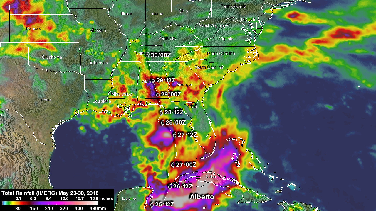
The Integrated Multi-satellitE Retrievals for GPM or IMERG is used to make estimates of precipitation from a combination of passive microwave sensors, including the GMI microwave sensor onboard the GPM satellite, and geostationary IR (infrared) data. This image shows IMERG rainfall estimates for the 1-week period 08:30 UTC 23 May to 08:00 UTC 30 May 2018 for the Southeast US, Gulf of Mexico and the surrounding region. IMERG estimates show upwards of 500 mm of rain (~20 inches) over the northwestern Caribbean; the bulk of which fell before Alberto actually formed due to the ongoing area of disturbed weather from which Alberto formed. Rainfall amounts of at least 5 to 15 inches (shown in dark red, purple and pink) cover most of western Cuba. Rainfall amounts over the southern Gulf are relatively light but pick up over the central Gulf where Alberto showed signs of strengthening before decreasing again over the northern Gulf. Over the Southeast US, summertime shower activity contributed about 2-4 inches (shown in yellow and red) over much of the area during this period as a resulf moist southerly flow. However, rainfall from the passage of Alberto pushes these rainfall totals to near 8 inches (shown in purple) over much of central Alabama, prompting several flood warnings, and is responsible for about 2-4 inches of rain over parts of mostly western Tennessee. Because of the storm's steady forward progress, rainfall amounts have not been as high as they could be. So far 2 deaths are being blamed on the storm in North Carolina and 4 in Cuba.