
Extreme Rainfall Along the Gulf Coast Measured by IMERG
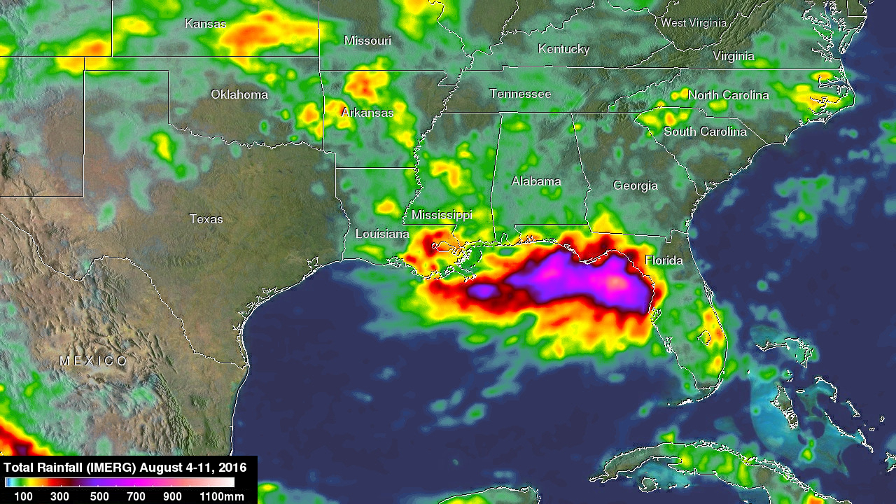
For the better part of a week, a persistent, mid-level area of low pressure has been tapping into warm, moist air to produce stormy weather in the northeastern Gulf Of Mexico. The National Hurricane Center (NHC) monitored this stormy area for possible development but unfavorable upper-level winds and the close proximity to land prevented development into a tropical system. However, during the past week from as much as 4 to over 15 inches (254-381 mm) of rain fell along the Gulf Coast from Tampa northward through the Big Bend to as far west as central Louisiana. So far the highest rainfall totals have been offshore, nevertheless street flooding has been common in Florida counties along the Gulf Coast due to locally heavy downpours.
NASA's Integrated Multi-satellite Retrievals for GPM (IMERG) data were used to make estimates of total rainfall over the Gulf Of Mexico during the period from August 4-11, 2016. These results show that the most extreme rainfall during this period fell over the waters of the northern Gulf Of Mexico south of the Florida Panhandle where IMERG estimates indicate that from 500 mm (~20 inches, shown in purple) to over 900 mm (~35 inches, shown in peach) of precipitation may have fallen. Over coastal areas, the highest totals are on the order of 300 to 400 mm (~12 to 16 inches, shown in dark red) and occur mostly along the northeast and north-central Florida Gulf Coast along with parts of southeastern Louisiana.
The lower pressure center responsible for triggering the showers and thunderstorms is expected to slowly retreat towards the northwest into the Lower Mississippi Valley bringing the threat for heavy rains and flooding to Louisiana. Parts of Lousiana, including New Orleans, and Mississippi Gulf Coast are forecast to see as much as 10 inches of additional rain over the coming days.