
GPM Catches a Look at a Rare Tornadic Storm Near the Chesapeake Bay
Tornadic storms in Maryland are rare to begin with, let alone in the middle of the night. However, about an hour after midnight in the early morning hours of Monday April 24th at around 1:00 am local time, a severe thunderstorm, which was located at the southern end of a mass of storms and which had just dumped heavy rains over the Washington, DC area, began to cross the Chesapeake Bay near Annapolis, Maryland heading eastward. It is quite common for storms to weaken as they cross the cooler waters of the Bay, but water temperatures are now rather warm, over 80F, which allowed the storm to intensify as it crossed from Annapolis towards the opposite shore. As it did, the now supercell thunderstorm spawned a waterspout just south of the Chesapeak Bay Bridge, which then intensified into an EF2 tornado that struck Kent Island around 1:30 am local time on the opposite shore from Annapolis and very near to the Bay Bridge. According to the National Weather Service, the tornado was on the ground for about 2 miles and had peak winds that were estimated at around 125 mph, making it an EF2 on the Enhanced Fujita tornado scale, which is considered a significant tornado. In addition to widespread roof and tree damage, the tornado was strong enough to destroy several townhomes entirely as well as the upper level of several others. Fortunately, only one person was injured.
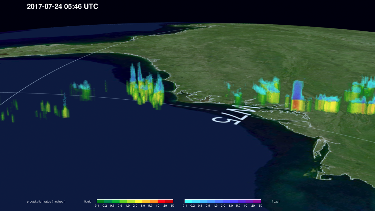
GPM captured this timely image of the storm soon after it had produced the tornado. The image was taken at 05:46 UTC (1:46 am EST) on Monday April 20th, about 15 minutes after the tornado struck Kent Island. The image shows both the 3D as well as the surface instantaneous precipitation rates estimated from the DPR. Rates above the height of the freezing level are shown in blues, while rates warmer than freezing and at the surface are shown in greens and reds. GPM reveals numerous thunderstorms scattered along the US East Coast, but one in particular stands out from the rest. Just to the right of the center, it is not hard to spot the supercell thunderstorm, which contains extremely heavy precipitation rates that extend much higher than the surrounding storms. Echo tops associated with this storm within the GPM swath were detected by the DPR to reach up to 14 km (over 45,000 ft). Although there were numerous storms present, many of which produced heavy rain, the Kent Island supercell was able to intensify much more and to acquire and concentrate the spin necessary to produce the tornado most likely as a result of two key ingredients: being at the southern end of the line where it had a better low-level inflow of warm, moist air and traveling along some type of atmospheric boundary that helped it to acquire rotation.
Visualization by Matthew Lammers (KBRWyle / NASA GSFC)
Image by George Fekete (NASA GSFC)
Caption by Stephen Lang (SSAI / NASA GSFC)