
GPM Measures The Altitudes of Hawaii's Rain And Snow
The mountains of Mauna Kea and Mauna Loa in the Hawaiian Islands have recently received heavy snowfall. Hawaii's balmy temperatures normally reach above 80 degrees Fahrenheit (27 C) at sea level on beaches such as Oahu's Waikiki but temperatures fall below freezing at the altitudes of tall mountain peaks on the Big Island. At 13,802 feet (4.2 km) Mauna Kea is Hawaii's tallest mountain. Snowfall is frequently seen on Mauna Kea's peak.
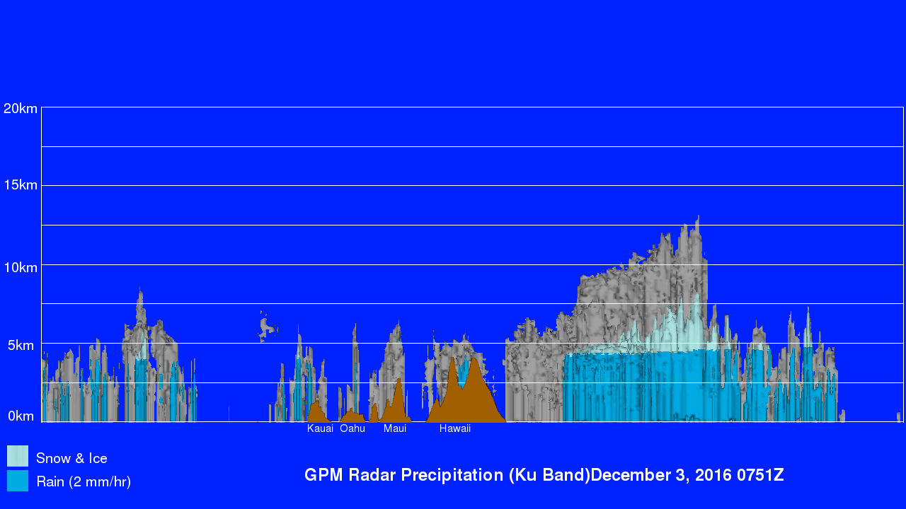
The nature of precipitation in the Hawaiian Islands was recently examined using data collected by the GPM core observatory satellite. GPM flew over the Hawaiian Islands on December 2, 2016 at 9:51 PM HST (December 3, 2016 at 0751 UTC) . Precipitation rates were calculated from data collected by GPM's Microwave Imager (GMI) and Dual-Frequency Precipitation Radar (DPR) instruments. DPR's radar (Ku Band) measured rain falling at the extreme rate of greater than 9.3 inches (~237 mm) per hour in intense storms southeast of the islands. Storm tops in that area were shown by GPM to reach altitudes above 41,000 feet (12.5 km). The height where freezing precipitation (snow and ice) fell was also determined by GPM's Dual-Frequency Precipitation Radar (DPR). The average freezing level in the area was found by GPM's DPR to be 14,127 feet (4.3 km) but sloped down to as low as 12,795 feet (3.9 km) just north of the Hawaiian Islands. This image illustrates the transition from liquid to frozen precipitation. Rain (darker aqua color) is indicated at lower elevations and snow and ice (lighter shades) are likely where temperatures were below freezing at the heights of Hawaii's tallest mountain peaks. This view from the west shows the heights of topography (brown) for all of the islands in the Hawaiian chain.