
Hurricane Nicole Lashes Bermuda
While powerful Hurricane Matthew drew a lot of attention as it made its way through the northern Caribbean and the Bahamas before ravaging the US East Coast with strong winds and massive flooding, another storm was lurking nearby in the western Atlantic--Nicole. Nicole, which like Matthew, also originated from a tropical wave that made its way across the central Atlantic from the coast of Africa. Nicole first became a tropical storm on the morning of the 4th of October about 525 miles northeast of San Juan Puerto Rico just after Matthew, a powerful Category 4 storm at the time, had devastated eastern Haiti. Unlike Matthew, Nicole meandered for many days about halfway between Bermuda to the north and the Virgin Islands to the south, trying to intensify while battling upper-level wind shear, including some of the outflow from Hurricane Matthew. On the afternoon of the 6th, Nicole became a hurricane before weakening again to a tropical storm. Nicole remained a tropical storm for the next several days before finally becoming a hurricane again on the afternoon of the 11th as wind shear over the storm relaxed. This time conditions remained favorable and Nicole began to strengthen steadily as it began to make its way northward then northeastward towards Bermuda. Nicole eventually reached a peak intensity of 115 knots (~132 mph), a Category 4 storm, on the evening of the 12th (local time) when it was about 200 miles SSW of Bermuda. Nicole continued to head straight for Bermuda where, having weakened slightly due to increasing southwesterly wind shear, it made a direct hit late on the morning of the 13th (local time) as a Category 3 storm with maximum sustained winds reported at 120 mph by the National Hurricane Center, making Nicole the strongest hurricane to hit Bermuda since Hurricane Fabian in 2003.
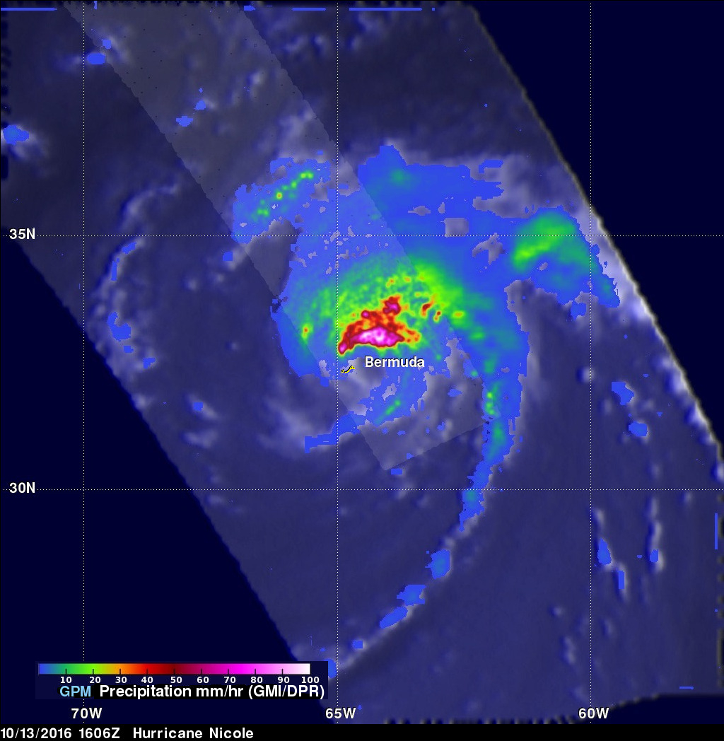
GPM captured this image of Nicole just after the storm had crossed over Bermuda at 16:06 UTC (12:06 pm EDT) on the 13th of October. The image shows rain rates derived from GPM's GMI microwave imager (outer swath) and dual-frequency precipitation radar or DPR (inner swath) overlaid on enhanced IR data from the GOES-East satellite. The rainfall pattern at this time is highly asymmetric with very intense rain rates on the order of 100 mm/hour (~4 inches per hour) located in the northern part of the eyewall with broad areas over heavy to moderate rain also wrapping around the northern half of the storm (red and green areas, respectively), while little to no rain is occurring south of the center. This is due to the effects of increasing southwesterly wind shear, which have exposed the southwestern part of the eye wall (gap in the rain field) and which would cause Nicole to continue to weaken as it continued to move northeastward away from Bermuda. Over the next few days, the National Hurricane Center is forecasting Nicole to weaken further and to continue moving to the northeast into the Central Atlantic.
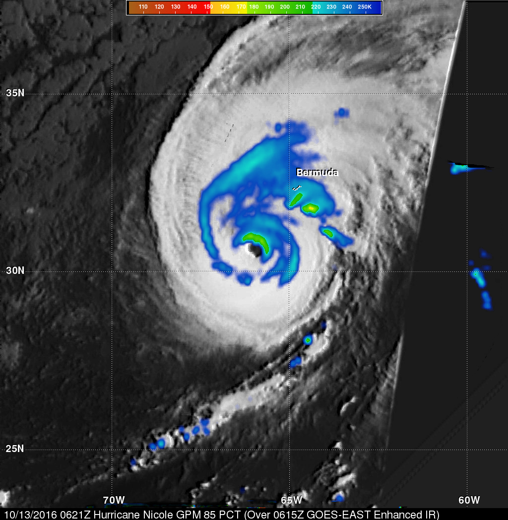
The GPM core observatory satellite also flew above Nicole earlier when the hurricane was approaching Bermuda on October 2016 at 0621 UTC (2:21 am EDT). GPM's Dual-Frequency Precipitation Radar (DPR) only viewed an area well east of Nicole's eye so it wasn't useful for evaluating the intensity of powerful convective storms near the center of the hurricane. In this image GPM's Microwave Imager (GMI) data alone were used to show the location and intensity of precipitation. This product called Polarization-Corrected Brightness temperatures (PCT), that combines vertically-polarized brightness temperature images, was used. The 250 K PCT (blue) is considered an indicator of moderate rain, 225 K PCT (aqua) is considered an indicator of deep convection, and lower PCTs (green to red) are considered indicators of more intense convection.