
Rainfall In Southeast Asia Analyzed By GPM
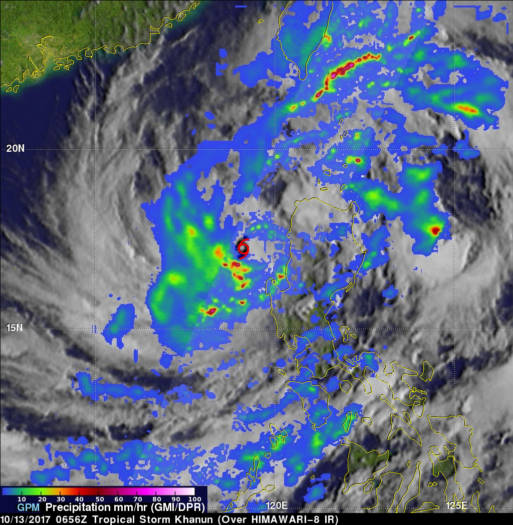
Tropical storm Khanun formed northeast of the Philippines on October 12, 2017. The GPM core observatory satellite passed above Khanun on October 13, 2017 (0656 UTC) when maximum sustained wind speeds had reached about 45 kts (~52 mph). Khanun had passed over the northern Philippines and was moving into the South China Sea. The approximate location of Khanun's center of circulation is shown with a red tropical storm symbol. The intensifying tropical storm's rainfall is shown in this image courtesy of data collected by GPM's Microwave Imager (GMI) and Dual-Frequency Precipitation Radar (DPR) instruments. GPM's Radar (DPR ku band) revealed that rain was falling at a rate of over 168 mm (6.6 inches) per hour within strong feeder bands wrapping around the southern side of the tropical cyclone.

This 3-d view of tropical storm Khanun's precipitation structure (looking toward the north) was derived from GPM's radar (DPR Ku Band). The intense band of thunderstorms south of Khanun's center of circulation were shown by DPR to reach heights of 15 km (9.3 miles). Even taller storms were made clear by GPM's radar in the Luzon Strait between the Philippines and Taiwan. Storm tops in a vigorous rain band north of Luzon were found by DPR reaching heights greater than 16.5 km (10.2 miles).
The Joint Typhoon Warning Center (JTWC) predicts that Khanun will soon become a typhoon as it moves west-northwestward over the South China Sea. Khanun is expected to have winds of about 80 kts (92 mph) as it approaches Hainan in a couple days. After hitting Hainan, typhoon Khanun is predicted to move over the Gulf Of Tonkin and impact northern Vietnam. Khanun will arrive less than a week after tropical depression twenty three (TD23) caused disastrous flooding and landslides in Vietnam. TD23 was responsible for the deaths of at least 54 people in northern and central Vietnam.

This rainfall accumulation analysis was derived from NASA's Integrated Multi-satellitE Retrievals data (IMERG). IMERG data are used to calculate estimates of precipitation from a combination of space-borne passive microwave sensors, including the GMI microwave sensor onboard the GPM satellite, and geostationary IR (infrared) data. This image shows IMERG rainfall estimates over Southeast Asia for the period from October 5-12, 2017 when TD23 was moving over Vietnam. IMERG estimates show that rainfall totals over north-central Vietnam were often greater than 300 mm (11.8 inches). During the same period, IMERG estimates indicated that more than 500 mm (19.7 inches) fell in an area of the South China Sea east of Hainan. The rainfall from newly formed tropical storm Khanun is shown accumulating in the northern Philippines.