
Tropical Storm Danny Forms in the Atlantic
Tropical Storm Danny became the 4th named storm of the season yesterday afternoon when it formed in the central Atlantic about 1660 miles east of the Windward Islands. Danny originated from an African easterly wave that moved off of the coast of Africa 4 days earlier on the 14th of August. Storms that form in this region are known as Cape Verde storms and typically form towards the height of hurricane season. In a typical season, there are about 10 named storms and 6 hurricanes. With this year being a potentially strong El Nino year, Atlantic hurricanes are usually suppressed. However, it only takes one. Hurricane Andrew, which devasted south Florida back in 1992, formed during an El Nino. Also, not all El Nino's are alike.
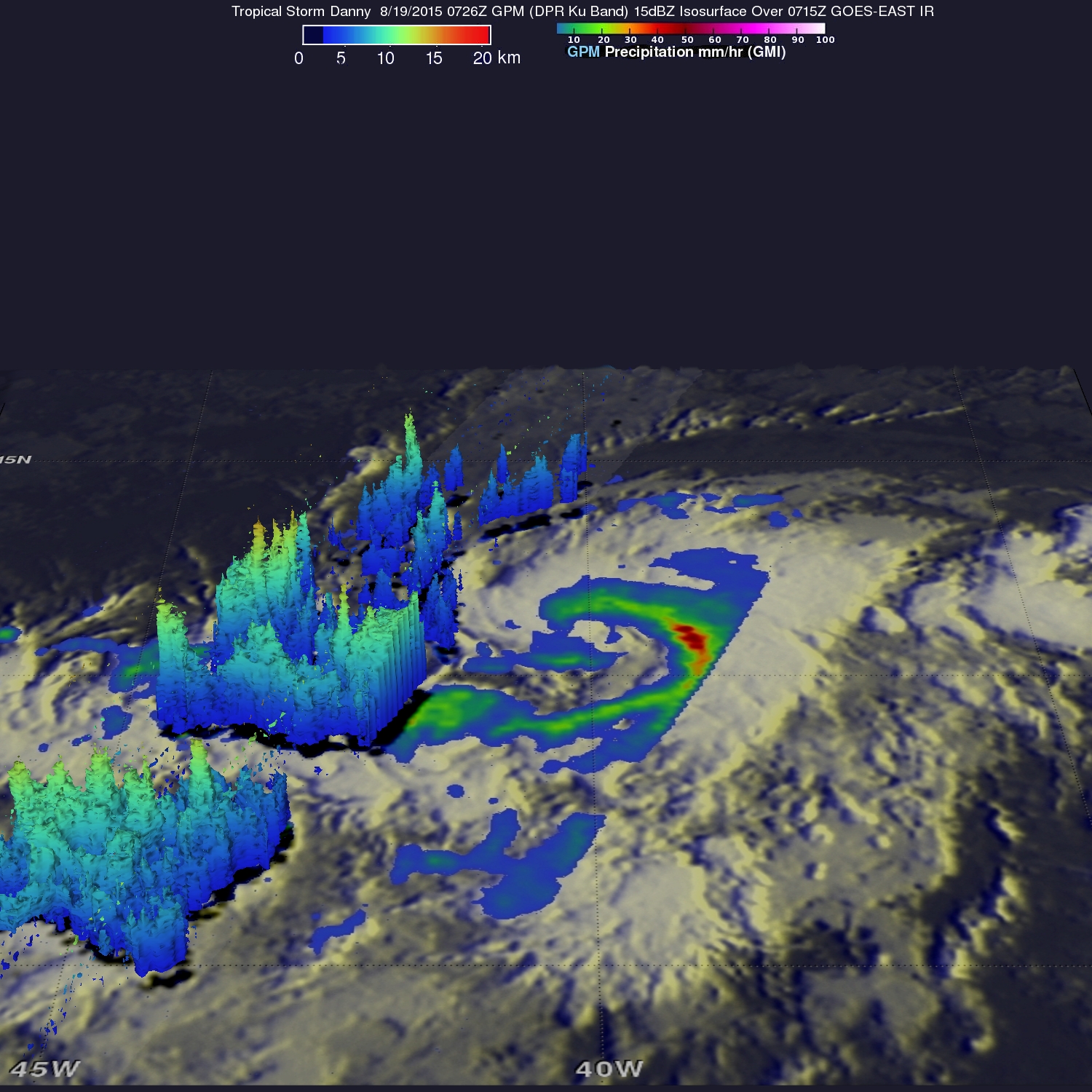
GPM captured this image of Danny, which is currently headed almost due west towards the Windward Islands, early this morning. The image was taken at 07:26 UTC (3:26 am EST) on the 19th of August and shows rain rates from the GMI overlaid on IR data from GOES East. The left hand side shows a 3D rendering of Danny where the GPM DPR (Dual- frequency Precipitation Radar) overflew the storm. At this time, GPM shows that Danny is still in the process of becoming organized. The rain structure is still very asymmetric as noted by the large rain band (identified by the green arc indicating moderate rain) being located mainly on the eastern side of the storm. Within this rain band, GPM detected rain rates of up to 73.9 mm/hour (shown in darker red). At the time of this image, Danny was still a minimal tropical storm with sustained winds estimated at 50 mph by the National Hurricane Center (NHC). Danny is over warm water, and the wind shear is light. Both of which are favorable for development. However, as noted by NHC, drier air maybe impeding the storm's development. Nonetheless, Danny is still forecast to become the first hurricane of the Atlantic season within the next day or so and remain a hurricane as it approaches the Windward Islands.
Click here to see a Low Resolution 512x512 (Quicktime) animation showing GPM rainfall on GOES-EAST.