TRMM Sees Deadly Louisiana Tornado
![]()
![]()
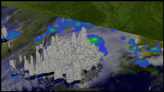
The TRMM satellite was flying high over head when it passed above tornadoes occurring in the state of Louisiana on 5 March 2011 at 1411 UTC (8:11 AM CST). The National Oceanic and Atmospheric Administration (NOAA) reported that seven tornadoes were spotted in Louisiana on that date. These tornadoes caused at least 15 injuries and one death with a tornado that hit in the northwest section of Rayne, Louisiana. The image on the left above shows a precipitation analysis using data collected with that TRMM orbit. TRMM's Microwave Imager (TMI) and Precipitation Radar (PR) (in the lighter swath) showed that extremely heavy rainfall was falling from these storms.
The image on the right above shows a view from the east using TRMM Precipitation Radar (PR) data. This 3-D slice through the storm shows that one of these powerful tornadic thunderstorms had intense echoes reaching as high as 15km (~9.3 miles).