
Monsoon, Tropical Cyclones Bring Massive Flooding to Manila
Over the past two weeks, a combination of the southwest monsoon and tropical cyclones passing in the vicinity of the northern Philippines has resulted in massive flooding in and around the Philippine capital. It is the worst flooding there since Typhoon Ketsana in 2009, which devastated Manila and killed over 400 people throughout the country. The current flooding began at the end of July with the passing of Typhoon Saola (known as Gener in the Philippines) northeast of Luzon. Although the center of Saola made landfall in northern Taiwan and passed well to the east of Luzon, the storm's cyclonic circulation enhanced the southwest monsoon, bringing heavy rains to the Philippines as warm, moist air brought in by strong southwesterly winds surged across the islands. Initial estimates put the death toll at 12 fatalities due to flooding and landslides.
After the passage of Saola, the monsoon continued to bring rain to the region. The southwest monsoon over the Philippines is part of the East Asian monsoon, a large scale circulation induced by the contrast in heating between land and ocean. As the Asian landmass heats up in the northern hemisphere summer, air begins to rise over the continent forming low pressure. The surrounding oceans, which heat up much less, appear relatively cool, setting up a giant sea breeze where cool moist air flows off the ocean towards lower pressure over the continent. As a result, southwest winds flow around IndoChina and over the South China Sea on their way to southern China, picking up moisture along the way.
A week after Saolo passed north of the Philippines, another tropical cyclone, Haikui, began passing north of the islands and the effects were again repeated. Like Saolo, Haikui formed in the Philippine Sea and passed near northern Taiwan. As with Saolo, southerly flow around the back side of the cyclone boosted the monsoon flow into the northern Philippines, bringing yet another round of heavy rains to the already water-soaked island of Luzon. During one 24-hour period, nearly 20 inches of rain were reported around Manila. The effects have been devastating with much of the city flooded. So far over 2 million people have been affected by the flooding. The combined death toll stands at 49 with several persons still missing.
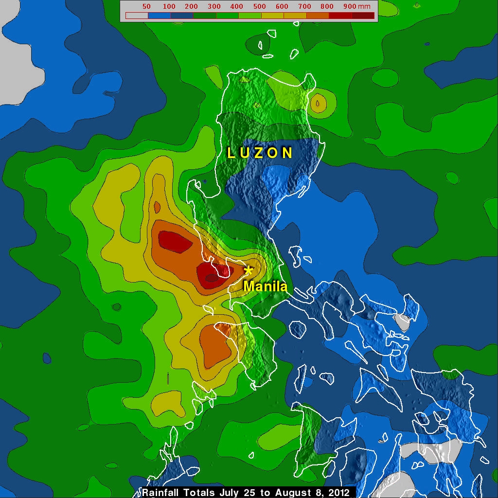
The TRMM-based, near-real time Multi-satellite Precipitation Analysis (TMPA) at the NASA Goddard Space Flight Center is used to monitor rainfall over the global Tropics. TMPA rainfall totals are shown here for the two-week period 25 July to 8 August 2012 for the northern Philippines and the surrounding region. The highest totals are over the southwestern part of Luzon where the southwest monsoon winds flowed in from the South China Sea. The highest totals are over 800 mm (~32 inches, shown in red) right along the coast west of Manila, while totals in and around the city are on the order of 500 mm (~20 inches, shown in yellow) or more. Rainfall totals on the western side of Luzon are generally much higher than those on the eastern side where as little as 50 mm (~2 inches, shown in blue) fell as the eastern side of Luzon was in the lee of the terrain with respect to the monsoon flow.