Philippines Devastated by Tropical Storm Washi
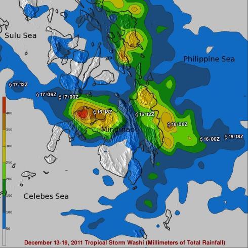
Washi, known locally in the Philippines as Sendong, began as a tropical depression on the 13th of December 2011 in the West Pacific Ocean about 2150 km (~1333 miles) due east of the southern Philippines. Washi only intensified slightly and never exceeded tropical storm intensity as it tracked due west towards the southern Philippines' island of Mindanao. Washi made landfall on the east coast of Mindanao on the afternoon of the 16th as a moderate tropical storm with sustained winds reported at 55 knots (~63 mph). Despite its modest intensity, Washi had a huge impact on the island. As Washi made its way across Mindanao, it dumped heavy rains over parts of the island, which in turn triggered flash floods and mudslides. These turned out to be catastrophic as over 700 people where killed with hundreds more reported missing when entire villages where swept away.
Rainfall estimates from the TRMM-based, near-real time Multi-satellite Precipitation Analysis (TMPA) at the NASA Goddard Space Flight Center are shown here for the period 13 to 20 December 2011 for the southern Philippines. Storm symbols mark Washi's track. Rainfall totals are on the order of 200 to over 250 mm (~8 to 10 inches, shown in green and yellow) along Mindanao's east coast where Washi made landfall, but the highest amounts are along the northwest coast, where totals are on the order of 300 to over 400 mm (~12 to over 16 inches, shown in orange and red). It was here in places like Cagayan de Oro City and Iligan City that the most devastating mudslides occurred. In addition to deforestation and weak construction, poor warnings are being blamed for the deadliest cyclone disaster to hit the Philippines in three years. The southern Philippines see far fewer cyclones per year than in the north, and most of the heavy rain was reported to have fallen over the mountains before flowing down in raging rivers.
See Earlier Images and Information about tropical storm Washi.


