
Tropical Cyclone Season Gets Started in the Northern Hemisphere
Summer has not yet arrived, and yet there are currently 3 active tropical systems in the Northern Hemisphere spread across three different ocean basins. Perhaps, the most unusual of the three is Tropical Storm Alberto in the Atlantic. Alberto formed in the western Atlantic from a stationary low pressure system off of the coast of South Carolina on the 19th of May 2012, two weeks before the official June 1st start of the Atlantic hurricane season. Alberto is the first tropical storm to form this early in the season since Tropical Storm Ana in 2003, which formed on the 20th of April west of Bermuda in the same general vicinity. The Tropical Rainfall Measuring Mission satellite (or TRMM) was placed into service way back in November of 1997. From its low-earth orbit, TRMM has been steadily providing valuable images and information on tropical cyclones around the Tropics using a combination of passive microwave and active radar sensors.
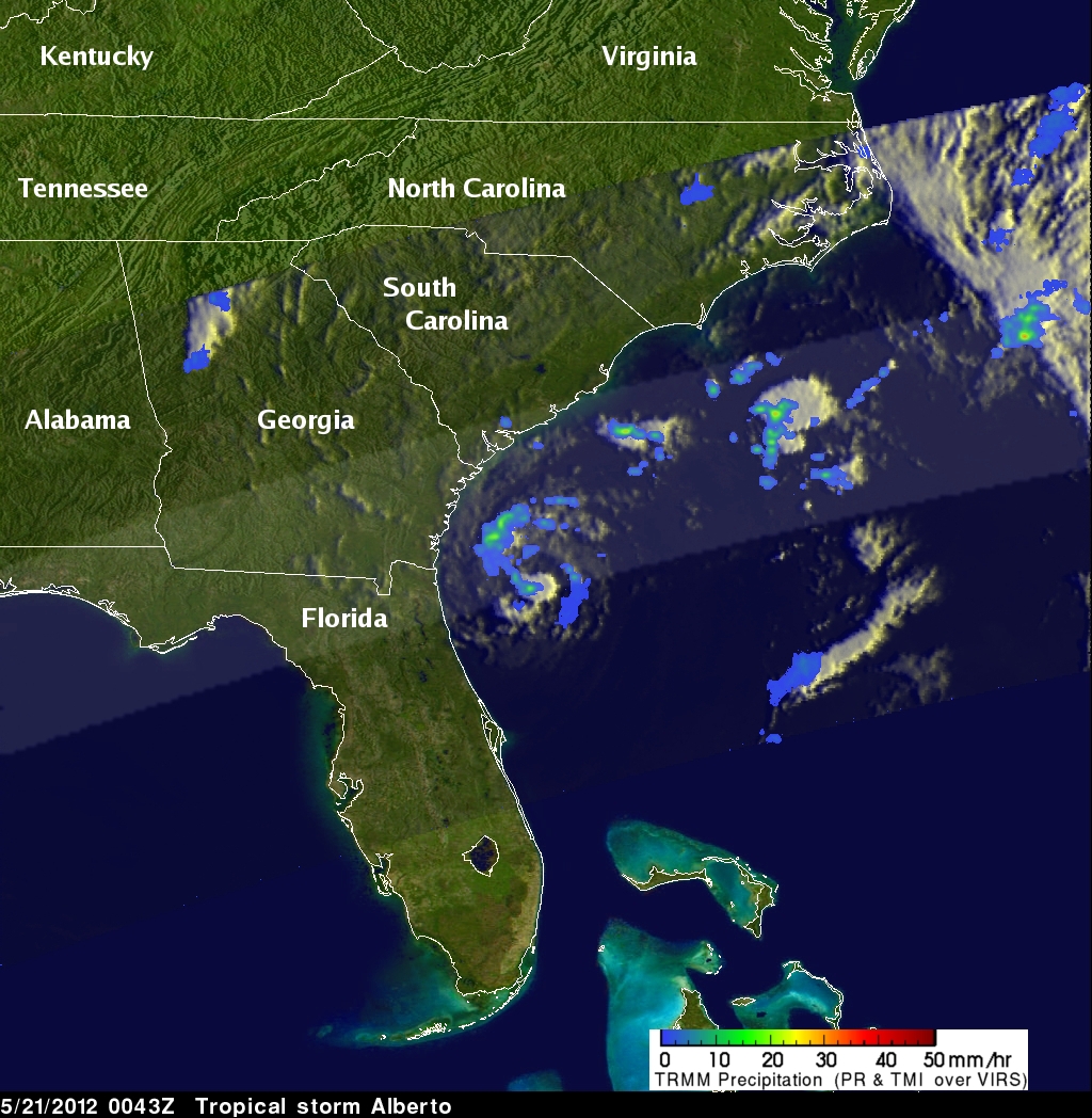
TRMM captured this recent image of Alberto at 00:43 UTC 21 May (8:43 pm EDT 20 May) 2012. It shows the horizontal pattern of rain intensity within the storm. Rain rates in the center swath are from the TRMM Precipitation Radar (PR), and those in the outer swath are from the TRMM Microwave Imager (TMI). The rain rates are overlaid on infrared (IR) data from the TRMM Visible Infrared Scanner (VIRS).
TRMM shows that Alberto (now located east of the Florida-Georgia border) has a small but well-defined circulation as evidenced by the sharp curvature in the spiral rain bands (the blue arcs); however, the storm has very little rain associated with it and no semblance of an eye. At the time of the image, Alberto was a weak tropical storm with sustained winds estimated at 40 knots (~46 mph) by the National Hurricane Center. Alberto is expected to turn to the northeast parallel to the coast and weaken to a depression well off of the East Coast. Despite the early arrival of Alberto, an early storm in this location does not indicate whether it will be an active season.

Meanwhile, over in the East Pacific, the second tropical system of the season there (TD #2E) is slowly getting organized. TD #2E formed on the evening of 20 May (local time) about 525 miles (845 km) south of Acapulco, Mexico. TRMM captured this image of TD #2E at 08:50 UTC (1:50 am PDT) 21 May soon after it formed. In contrast to Alberto, TD #2E shows very little banding but much more precipitation with areas of moderate rain (shown in green) embedded throughout. The system is located in the center of the image and is associated with the northernmost mass of rain.
The East Pacific season also began early when Tropical Storm Aletta formed on the 14th of May, one day before the official start of the season. TD #2E is still in its formative stages but is expected to strengthen and could become the first hurricane in the East Pacific.

Finally out in the West Pacific, a tropical depression is passing near Guam. TD #3W, the third depression of the year in the West Pacific, formed on the afternoon of 21 May (local time) about 300 km (~185 km) south-southeast of the island.
This image from TRMM as taken at 06:40 UTC (4:40 pm local time) 21 May just as TD #3W was forming. Again as with TD #2E in the East Pacific, there is not yet any evidence of banding with this system though there are some isolated areas of intense rain (indicated by the dark red spots) associated with active convection. TD #3W is expected to become a tropical storm before recurving west of Guam. Unlike, the Atlantic and East Pacific, which have distinct hurricane seasons, storms can occur throughout the year in the West Pacific though they peak in September with a minimum in February and March.
TRMM is a joint mission between NASA and the Japanese space agency JAXA.