
Tropical Cyclones bring Heavy Rains to the Far East
Over a period of 10 days, a series of three tropical cyclones brought heavy rains and devastating flooding to parts of the Philippines, southern China and Vietnam. The first of these storms to form--and the most devastating--was Typhoon Nesat, which began in the central Philippine Sea. This storm intensified as it tracked westward reaching Category 3 intensity just before making landfall on the northern Philippines island of Luzon early on the morning of the 27th of September. It brought heavy rains and widespread flooding to the region and was initially blamed for 56 fatalities in the Philippines with 28 more reported missing. After crossing Luzon, Nesat continued heading westward over the South China Sea toward southern China. Just as Nesat was bearing down on the Philippines, a second tropical cylcone, Tropical Storm Haitang, formed off the coast of central Vietnam. It made landfall near Hu, Vietnam at nearly the same time as Nesat was making landfall in the Philippines. Haitang was a much weaker storm and never exceeded tropical storm intensity. It did, however, bring heavy flooding to central Vietnam where it was blamed for 7 deaths. Meanwhile, after having crossed the northern South China Sea, Nesat swept over the southern Chinese island of Hainan and the coastal province of Zhejiang before continuing on into northern Vietnam. It was blamed for 4 fatalities in China; the final death toll in Vietnam from both Haitang and Nesat was 18. The final storm in the series--and also the strongest--was Typhoon Nalgae. It too formed in the Philippine Sea east of the Philippines and followed a path quite similar to Nesat. It made landfall on the northern Philippines island of Luzon on the morning of October 1st at nearly the same location as Nesat but as an even stronger Category 4 super typhoon. In the Philippines, the total number of people reported killed from from both Nesat and Nalgae was 82. Just as with Nesat, Nalgae also crossed Luzon and continued on towards southern China, crossing over Hainan before continuing on into Vietnam.
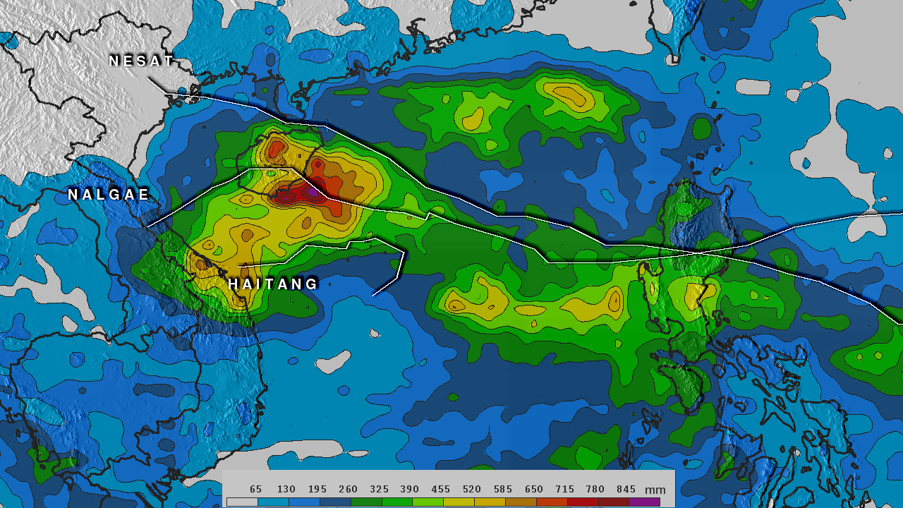
Rainfall estimates from the TRMM-based, near-real time Multi-satellite Precipitation Analysis (TMPA) at the NASA Goddard Space Flight Center are shown here for the period 23 September to 5 October 2011 over the West Pacific region. Thin solid white lines mark the tracks of the various storms. The highest rainfall totals appear over Hainan, which felt the effects of both Nesat and Nalgae, where they range as high as 650 mm (~26 inches, shown in orange). Elsewhere over the northern Philippines, much of northern Luzon received in excess of 260 mm (~10 inches, shown in dark green) with some areas exceeding 455 mm (~18 inches, shown in yellow). The last area to see significant flooding was central Vietnam where rainfall totals reached on the order of 600 mm (~24 inches, shown in dark yellow).