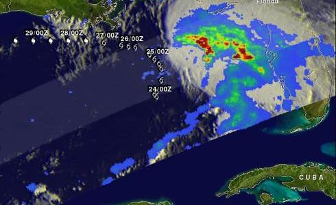
Tropical Storm Debby
The TRMM satellite traveled directly above tropical storm Debby's location early this morning at 0656 UTC ( 2:56 AM EDT). TRMM Microwave Imager (TMI) and Precipitation Radar (PR) data from that pass shows that Debby was dropping heavy rainfall in a large area on the eastern side of the Gulf Of Mexico. Most of the powerful convective storms producing this rainfall are shown by TRMM to be located well to the northeast of Debby's center of circulation.
A forecast track from the National Hurricane Center (NHC) was overlaid on the image above. It shows that Debby is expected to stengthen and travel westward parallel to the Gulf coast over the next few days.


