
Tropical Storm Debby Drenches Florida
Even though it never became more than a tropical storm, the residents of northern and central Florida will remember Debby. Debby, which formed as a tropical storm on the 23rd of June 2012 in the central Gulf of Mexico, took three full days to reach the Big Bend of Florida just 350 miles away. Although the center didn't make landfall until around 5 pm on the afternoon of the 26th when it crossed the coast near Steinhatchee, Florida, Debby's effects were felt well away from the center. Most of the rain and weather associated with Debby were well to the north and east of the center over Florida, which was effectively inundated with rain squalls originating over the Gulf and wrapping around the eastern side of the storm for 3 days. The result was copious amounts of rain over the central and northern parts of the state in addition to an outbreak of tornadoes over central and southern Florida on the 24th.
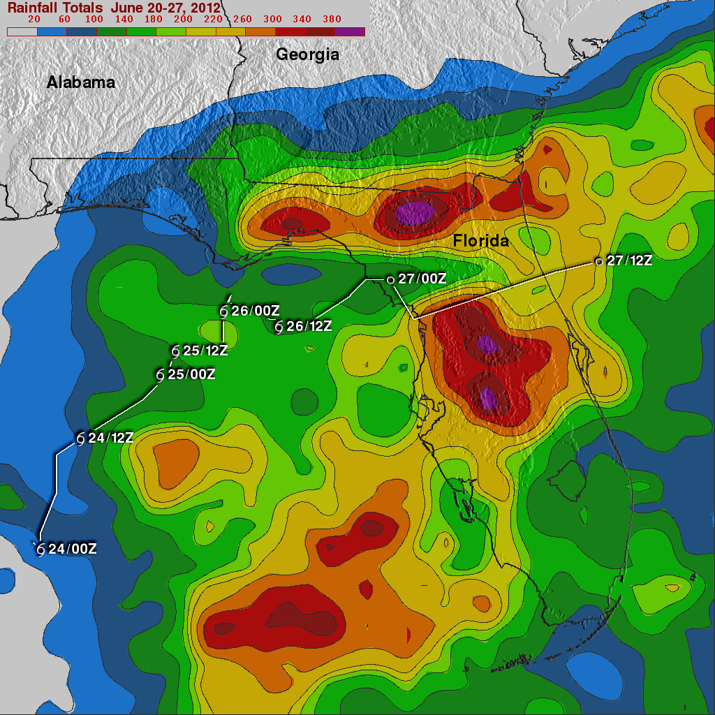
In addition to capturing detailed images of tropical storms, TRMM is ideally suited to measure rainfall from space. For increased coverage, TRMM is used to calibrate rainfall estimates from other additional satellites. The TRMM-based, near-real time Multi-satellite Precipitation Analysis (TMPA) at the NASA Goddard Space Flight Center is used to estimate rainfall over a wide portion of the globe. TMPA rainfall totals are shown here for the 7-day period 20 to 27 June 2012 over and around Florida. The highest rainfall totals for the period are in excess of 380 mm (~15 inches, shown in purple). The heaviest rains cover a wide patch of central Florida from around Titusville on the east coast to around Homosassa Springs on the west coast within which amounts exceed 260 mm (~10 inches, shown in orange) to over 380 mm in the center. Another band of heavy rain is oriented east-west across northern Florida from Jacksonville to near Tallahassee with similar amounts or rain. The highest totals in the band occur around Lake City and exceed 380 mm. This east-west band can be attributed to the interaction of Debby's counterclockwise circulation with the coast and a frontal boundary draped across southern Georgia in an east-west orientation.
After coming ashore, Debby was downgraded to a tropical depression as it crossed northern Florida. The center is now moving out into the Atlantic away from Florida, reducing the threat for more heavy rain.
Click here to see earlier TRMM related information about Debby.