Tropical Storm Debby Threatens Florida Gulf Coast
Tropical Storm Debby formed on the 23rd of June 2012 in the central Gulf of Mexico, becoming the earliest 4th named storm on record. Debby began as an area of low pressure that moved out of the northwestern Caribbean and into the Gulf. After forming on the afternoon of the 23rd, Debby has moved very slowly under the influence of weak steering currents. Debby drifted ever so slowly northward on the night of the 23rd before turning northeast later on the morning of the 24th towards the northeast Gulf Coast of Florida. Despite its slow forward progress and lack of intensification, Debby has already lashed Florida with heavy rain as well as tornadoes.
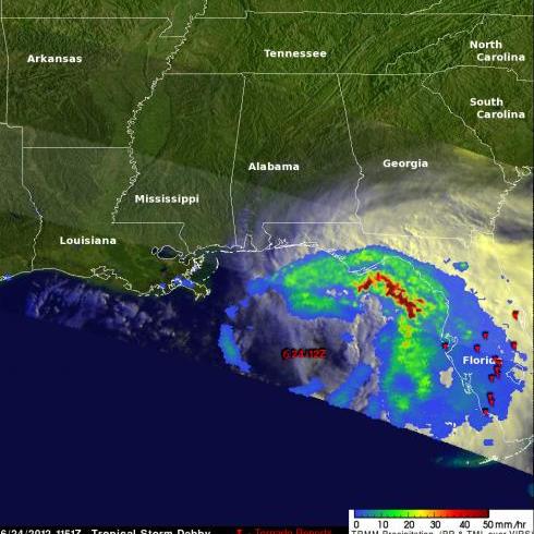
The Tropical Rainfall Measuring Mission (or TRMM) satellite captured this image of Debby when it passed over the storm in the north central Gulf of Mexico on the morning of the 24th. The image was taken at 11:51 UTC (6:51 AM CDT) on 24 June 2012. The image shows a top-down view of the rain intensities within Debby. Rain rates in the center of the swath are from the TRMM Precipitation Radar (PR), while those in the outer swath are from the TRMM Microwave Imager (TMI). The rainrates are overlaid on infrared (IR) and visible data from the TRMM Visible Infrared Scanner (VIRS). TRMM reveals that most of the rain associated with Debby is well away from the center (which is marked by the storm symbol). A large area of moderate rain (shown in green) north and east of the center extends from near Tampa Bay all the way around to near Panama City. A large band of intense rain (shown in darker red) lies just off shore, while light (blue areas) to moderate rain covers a broad area of the Florida peninsula. Tornado symbols mark the locations of tornado reports; one woman was reportedly killed by a twister in the central part of the state. At the time of this image, Debby was a moderate tropical storm with sustained winds reported at 60 mph by the National Hurricane Center.
Click here to see an animated blend from the infrared (IR) and visible data to TRMM TMI/PR rainfall data.
The center of Debby is currently located about 50 miles (~80 km) south southwest of Apalachicola and moving very slowly to the northeast. Debby is expected to move slowly eastward and cross northern Florida. The storm is also expected to continue to bring very heavy rains to northern and central Florida where some areas could see in excess of 20 inches of rain. Storm speed is what matters most when it comes to rainfall; the slower the storm, the more time it has to rain over a given area. Debby dumped nearly 7 inches of rain on Gainesville Sunday, their second highest one day total, while numerous other reports of between 6 and 10 inches of rain have already been reported as a result of Debby.


