Tropical Systems bring Heavy Rain to Mexico and Central America
Within just the past week, the East Pacific has seen a resurgence in tropical activity with the formation of three tropical systems: two hurricanes and a depression. Two of the systems, the two that would go on to become hurricanes, formed on the evening and night of 5 October 2011. The first was TD #10E, the 10th tropical depression of the season in the East Pacific. It formed about 1000 km (~625 mi) south of the Mexican coast and later strengthened into Hurricane Jova. Jova intensified to a Category 3 hurricane before eventually making landfall as a Category 2 storm on Wednesday October 12th west of Manzanillo on the Pacific coast of Mexico. Jova is being blamed for 6 fatalities in Mexico. TD #11E, which formed soon after TD #10E, also went onto become a hurricane, Irwin. Irwin, however, only maintained Category 1 intensity for about a day before weakening to a tropical storm. After forming well off the coast about 1400 km (~880 mi) south of Baja, California, it eventually made its way to within 100 miles (~150 km) of the coast on the 13th, close to where Jova made landfall, before turning away and heading back out to sea. Irwin is now a minimal tropical storm and moving away from land. Although it was the weakest of the three systems, TD #12E turned out to be the deadliest. It formed in the early morning hours of the 12th of October and quickly came ashore in southern Mexico north of the Guatemalan border. Despite the system's lack of intensity, the region is vulnerable to flash floods and mudslides due to the area's steep topography. So far at least 24 people have died as a result of the storm, most in Guatemala where 15 were reported to have died mainly from flooding and mudslides where the storm's counter-clockwise circulation drew moist air over the mountainous terrain.
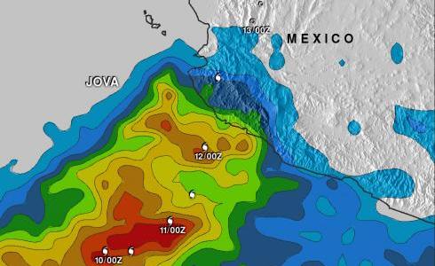
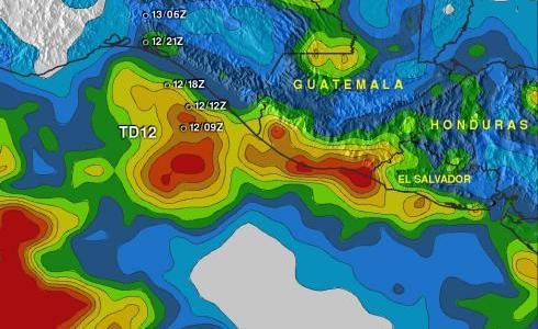
Rainfall estimates from the TRMM-based, near-real time Multi-satellite Precipitation Analysis (TMPA) at the NASA Goddard Space Flight Center are shown here for the period 6 to 13 October 2011 for the central as well as the southern Pacific coast of Mexico near Central America. Appropriate storm symbols mark the track and intensity of the various storms. The highest rainfall totals over the central coast of Mexico in association with Hurricane Jova are on the order of 100 to 150 mm (~4 to 6 inches, shown in green and yellow, respectively) and rapidly fall off away from the coast as Jova quickly moved inland. Farther south, the rainfall amounts associated with TD #12E are significantly higher. Right along the coast of Guatemala, amounts exceed 200 mm (~8 inches, shown in brown) to as much as 250 mm (~10 inches, shown in red). Rainfall amounts also drop off further inland, but there are still significant amounts ranging from around 50 mm (~2 inches, shown in blue) to as much as 200 mm that extend across southern Mexico and much of Guatemala, Honduras and El Salvador. Some of this rain originated from a monsoon trough in the region.
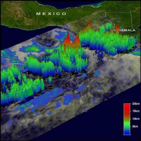
 The final image shows a 3D depiction of what would later become TD #12E. The image was taken from the TRMM Precipitation Radar or PR at 15:25 UTC (8:25 am PDT) on 11 October 2011. TRMM shows a large area of rain along the coast of Guatemala. Near the center of the image tall towers (shown in red) reveal areas of deep convection near what would become the center of TD #12E. These tall towers are often a sign of intensification. TD #12E formed less than 18 hours after this image was taken.


